Antonine Wall distance slabs
There are 18 known Antonine Wall distance slabs
The slabs are overwhelmingly concentrated in the western half of the Wall. Keppie already observed that only two of the eighteen known slabs belonged to the eastern half, and Hanson and Tomlin reaffirm that pattern while revising several proposed slab-locations and work-sectors. The broad consensus remains that the Wall was begun from the east and that the western terminal sector between Castlehill and Old Kilpatrick was later subdivided into six short sections measured in feet, unlike the eastern and central sections, which were generally measured in paces. [2]
Most secure slabs are now in The Hunterian, University of Glasgow; the great exception is the Bridgeness slab in the National Museum of Scotland, while RIB 2194 is in Kelvingrove Art Gallery and Museum. RIB 2198 is exceptional again: the original was taken to Chicago and destroyed in the fire of 1871, so only casts survive. [3]
On the broad question of function, recent scholarship strongly reasserts that the slabs commemorate work on the Wall/rampart, not on the Military Way. [4]
Corpus definition and method
The eighteen secure inscribed slabs are listed below plus two suspected extras so that the list is complete in the modern scholarly sense. References are to Roman Inscriptions of Britain Online, National Museums Scotland, and museum/collection references; for work-sector interpretation and disputes I have prioritised Keppie’s excavation and epigraphic studies and Hanson and Tomlin’s 2025 critical overview. [5]
Summary table (in order from west to east)
| Slab ID | Findspot | Legion(s) | Current location | Image link |
|---|---|---|---|---|
| RIB 2139 | Bridgeness, Bo’ness | II Augusta | National Museum of Scotland, X.FV 27 | RIB 2139 page |
| RIB 2173 | Unprovenanced on Antonine Wall, probably east of Auchendavy or central-eastern sector | XX Valeria Victrix | Hunterian, GLAHM F.1 | RIB 2173 page |
| RIB 2185 | Eastermains/Inchbelly Bridge, east of Kirkintilloch | VI Victrix Pia Fidelis | Hunterian, GLAHM F.2 | RIB 2185 page |
| RIB 2184 | Eastermains, east of Kirkintilloch | XX Valeria Victrix | Hunterian, GLAHM F.3 | RIB 2184 page |
| RIB 2186 | Cadder/Cawder House, probably Bogton sector | II Augusta | Hunterian, GLAHM F.4 | RIB 2186 page |
| RIB 2193 | Summerston, near Balmuildy fort | II Augusta | Hunterian, GLAHM F.5 | RIB 2193 page; |
| RIB 2194 | East Millichen, near Balmuildy fort | VI Victrix Pia Fidelis | Kelvingrove Art Gallery & Museum, A.1942.18.01 | RIB 2194 page |
| RIB 2196 | Castlehill | VI Victrix Pia Fidelis | Hunterian, GLAHM F.6 | RIB 2196 page |
| RIB 2197 | Castlehill, south lip of ditch | XX Valeria Victrix | Hunterian, GLAHM F.7 | RIB 2197 page |
| RIB 2198 | Hutcheson Hill, west of Castlehill | XX Valeria Victrix | Original destroyed; casts at Hunterian, GLAHM F.8, and elsewhere | RIB 2198 page |
| RIB 3507 | Cleddans Farm, Hutcheson Hill sector | XX Valeria Victrix | Hunterian, F.1969.22 | RIB 3507 page |
| RIB 2199 | Probably Cochno Estate/Duntocher area, but provenance disputed | XX Valeria Victrix | Hunterian, GLAHM F.11 | RIB 2199 page |
| RIB 2200 | Braidfield Farm, east of Duntocher | VI Victrix Pia Fidelis | Hunterian, GLAHM F.9 | RIB 2200 page |
| RIB 2203 | Duntocher Burn, west of Duntocher fort | II Augusta | Hunterian, GLAHM F.10 | RIB 2203 page |
| RIB 2204 | Carleith, west of Duntocher fort | II Augusta | Hunterian, GLAHM F.12 | RIB 2204 page |
| RIB 2205 | Old Kilpatrick, probably Dalnotter sector | VI Victrix Pia Fidelis | Hunterian, GLAHM F.13 | RIB 2205 page |
| RIB 2206 | Old Kilpatrick, probably Dalnotter sector | XX Valeria Victrix | Hunterian, GLAHM F.14 | RIB 2206 page |
| RIB 2208 | Ferrydyke, west of Old Kilpatrick | XX Valeria Victrix | Hunterian, GLAHM F.15 | RIB 2208 page |
Distance Slabs from Bridgeness to Castlehill
RIB 2139 — the Bridgeness slab, Bridgeness, Bo’ness.

Legion/inscription: Imp(eratori) Caes(ari) Tito Aelio Hadri(ano) Antonino Aug(usto) Pio p(atri) p(atriae) leg(io) II Aug(usta) per m(ilia) p(assuum) IIII DCLII fec(it), with vexillum leg(io) II Aug(usta). Translation: “For the Emperor Caesar Titus Aelius Hadrianus Antoninus Augustus Pius, father of his country, the Second Legion Augusta built this work for a distance of 4,652 paces.” Physical description: sandstone; about 2.74–2.75 m wide, c. 0.86–0.89 m high; monumental central inscription, battle scene to left, suovetaurilia to right, clamp-holes for mounting, traces of original paint reported. Location/accession: National Museum of Scotland, X.FV 27. Context/date: found face-down in 1868 on Windmill Hill at Bridgeness, very close to the accepted eastern terminus; usually dated c. AD 142–3. Consensus/dispute: this is the single strongest positive marker for the wall’s eastern end, although limited excavations near the findspot failed to recover the rampart itself, reviving a Carriden alternative; Hanson and Tomlin nevertheless conclude Bridgeness remains the best indicator of the terminus. [26]
RIB 2173 — usually the “Auchendavy” or unprovenanced eastern-central slab

Legion/inscription: Imp(eratori) Caesari T(ito) Aelio Hadriano Antonino Aug(usto) Pio p(atri) p(atriae) vexillatio leg(ionis) XX Val(eriae) Vic(tricis) f(ecit) per mil(ia) p(assuum) III. Translation: “For the Emperor Caesar Titus Aelius Hadrianus Antoninus Augustus Pius, father of his country, a detachment of the Twentieth Legion Valeria Victrix built this work for a distance of three miles.” Physical description: buff sandstone, 0.965 × 0.838 m; broken across the middle; decorative ivy tendrils and peltae, with griffin-like terminals, and cramp-holes suggesting insertion within masonry. Location/accession: Hunterian, GLAHM F.1. Context/date: found “on the Antonine Wall” in 1581–1607; later at Dunnottar Castle, then Marischal College, Aberdeen, and at Glasgow from 1761; RIB dates it AD 142–161. Consensus/dispute: provenance is the main problem. RIB says it was variously assigned to Cadder Manor or Balmuildy, while Campbell and Hanson–Tomlin both treat it as an eastern-central slab, commonly placed east of Auchendavy or in the Tamfourhill–Seabegs sector, but without secure archaeological provenance. [9]
RIB 2185 — Eastermains / Inchbelly Bridge slab.

Legion/inscription: Imp(eratori) Caesari T(ito) Aelio Hadriano Antonino Aug(usto) Pio p(atri) p(atriae) vexilla(tio) leg(ionis) VI Vic(tricis) P(iae) F(idelis) per m(ille) p(assus). Translation: “For the Emperor Caesar Titus Aelius Hadrianus Antoninus Augustus Pius, father of his country, a detachment of the Sixth Legion Victrix Pia Fidelis (built) for a distance of one mile.” Physical description: buff gritstone, c. 1.6 × 0.762 m; fractured down the middle. Location/accession: Hunterian, GLAHM F.2. Context/date: found c. 1740 a little west of Inchbelly Bridge, about 1.6 km north-east of Kirkintilloch fort. Consensus/dispute: this is one of the key “unfinished or incomplete?” slabs. RIB reports the traditional interpretation as a completed one-mile record, while Keppie and Hanson–Tomlin prefer to see it as a slab prepared in advance for a longer sector but left without its numeral, perhaps to be completed later in paint. In sector-reconstructions it is normally assigned to the Girnal Hill–Eastermains stretch. [28]
RIB 2184 — Eastermains slab from the ditch.

Legion/inscription: leg(io) XX V(aleria) V(ictrix) fec(it) m(ilia) p(assuum) III p(edum) III CCCIV. Translation: “The Twentieth Legion Valeria Victrix built 3 miles, 3304 feet.” Physical description: buff sandstone, 0.584 × 0.432 × 0.356 m; block-like slab from the ditch. Location/accession: Hunterian, GLAHM F.3. Context/date: found face-down in the Antonine ditch on Eastermains farm in 1789, east of Kirkintilloch fort. Consensus/dispute: the interest here is the mixed measurement, which Macdonald and later writers read as 3 miles plus 3304 feet, yielding 3660.8 paces; Hanson and Tomlin still use it in reconstructing the Eastermains–Cadder sector. The small size and omission of the emperor fit the pattern noted in modern scholarship for some pre-prepared or compact western-central stones. [29]
RIB 2186 — Cadder / Cawder House slab.

Legion/inscription: Imp(eratori) Caes(ari) Tito Aelio Hadriano Antonino Aug(usto) Pio p(atri) p(atriae) leg(io) II Aug(usta) per m(ilia) p(assuum) III DCLXVI s(emis). Translation: “For the Emperor Caesar Titus Aelius Hadrianus Antoninus Augustus Pius, father of his country, the Second Legion Augusta (built this) for a distance of 3,666½ paces.” Physical description: buff sandstone, overall 0.914 × 0.635 m, originally c. 1.03 × 0.65 m. Location/accession: Hunterian, GLAHM F.4. Context/date: provenance unknown beyond Cadder; by 1604 it was already re-used in Cawder House, west of Cadder fort. Consensus/dispute: the main issue is provenance, not attribution. RIB notes earlier wrong assignment to Balmuildy; Macdonald placed it most plausibly on the farm at Bogton east of Cadder fort. Hanson and Tomlin treat it together with Summerston as defining the II Augusta 3666½-pace sector from Cadder to Summerston. [30]
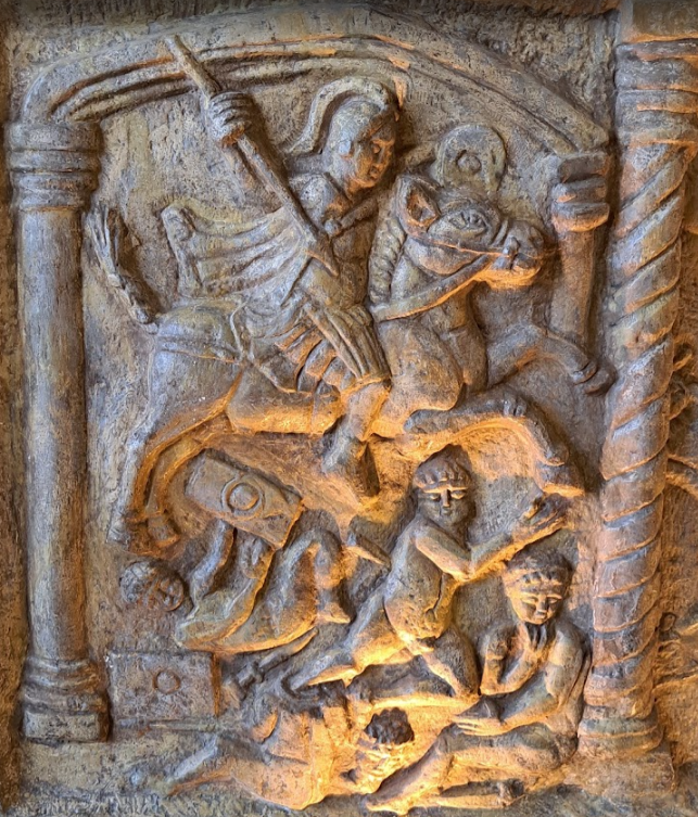
RIB 2193 — the Summerston slab

Legion/inscription: Imp(eratori) Caes(ari) Ti t o Aelio Hadriano An t o ni no Aug(usto) Pio p(atri) p(atriae) leg(io) II Aug(usta) pe<r=p> m(ilia) p(assuum) III DCLXVI s(emis). Translation: “For the Emperor Caesar Titus Aelius Hadrianus Antoninus Augustus Pius, father of his country, the Second Legion Augusta (built this) for a distance of 3,666½ paces.” Physical description: buff sandstone, 1.346 × 0.61 m; broken in two; elaborate figural sculpture with Victory, horseman, captives, eagle and Capricorn. Location/accession: Hunterian, GLAHM F.5. Context/date: found on the line of the Wall near Summerston, about 400 m north-west of Balmuildy fort; in Glasgow by 1694. Consensus/dispute: Gordon wrongly assigned it to Castlehill. Hanson and Tomlin emphasise that the “foundation of stone” in early accounts refers to the Wall base, against Campbell’s recent Military Way reading; it stands with RIB 2186 in the Cadder–Summerston sector. [31]
RIB 2194 — East Millichen slab.
Image: RIB page; current museum object is in Glasgow Museums/Kelvingrove. Legion/inscription: Imp(eratori) Caes(ari) T(ito) Aelio Hadri(ano) Antonino Aug(usto) Pio p(atri) p(atriae) vexilla(tio) leg(ionis) VI Vic(tricis) P(iae) F(idelis) per m(ilia) p(assuum) III ĐCLXVI s(emis). Translation: “For the Emperor Caesar Titus Aelius Hadrianus Antoninus Augustus Pius, father of his country, a detachment of the Sixth Legion Victrix Pia Fidelis (built this) for a distance of 3,666½ paces.” Physical description: buff sandstone, 1.473 × 0.762 m. Location/accession: Kelvingrove Art Gallery and Museum, accession A.1942.18.01. Context/date: found in 1803 at East Millichen, c. 90 m south of the Wall and over 800 m north-west of Balmuildy fort; RIB notes it must have been moved from its position on the line. Consensus/dispute: no legion dispute. The scholarly interest is that it probably stood beside RIB 2193 at the junction between the II and VI sectors, and Hanson–Tomlin use its cramped numerals as evidence that some slabs were prepared before exact measurements were finalised. [32]
RIB 2196 — Castlehill slab of VI Victrix.

Image: RIB page. Legion/inscription: Imp(eratori) Caesar(i) T(ito) Aelio Hadriano Antonino Aug(usto) Pio p(atri) p(atriae) vexilla ti o leg(ionis) VI Vic tr(icis) P(iae) F(idelis) per m(ilia) p(assuum) III ĐCLXVI s(emis). Translation: “To the Emperor Caesar Titus Aelius Hadrianus Antoninus Augustus Pius, father of his country, a detachment of the Sixth Legion Victrix Pia Fidelis (built this) for a distance of 3,666½ paces.” Physical description: buff gritstone, 1.499 × 0.762 m. Location/accession: Hunterian, GLAHM F.6. Context/date: seen built into a cottage at Castlehill before 1698; evidently from the Castlehill fort sector. Consensus/dispute: paired by modern reconstructions with RIB 2194 in the Summerston–Castlehill VI sector. Hanson and Tomlin point to awkward layout and surplus space on the panel as further evidence that the slab was prepared before the final digits were inserted. [33]
RIB 2197 — Castlehill slab of XX Valeria Victrix.

Legion/inscription: Imp(eratori) C(aesari) T(ito) Aelio Hadriano Antonino Aug(usto) Pio p(atri) p(atriae) vex(illatio) leg(ionis) XX V(aleriae) V(ictricis) p(er) p(edum) III (milia). Translation: “For the Emperor Caesar Titus Aelius Hadrianus Antoninus Augustus Pius, father of his country, a detachment of the Twentieth Legion Valeria Victrix (built this) for a distance of 3000 feet.” Physical description: buff sandstone, 0.813 × 0.711 m; partial, with the right margin broken by the plough and a central upper dowel-hole. Location/accession: Hunterian, GLAHM F.7. Context/date: found in 1847 on the south lip of the ditch at Castlehill, more than 1 m below the surface. Consensus/dispute: Hanson and Tomlin explicitly reject a recent conflation of this findspot with Hutcheson Hill; for them the near-contemporary Ordnance Survey location is reliable, and the slab marks the start of the 3000-foot western subgroup that ended at Hutcheson Hill. [16]
Distance Slabs from Hutcheson Hill to Old Kilpatrick
RIB 2198 — destroyed Hutcheson Hill slab

Legion/inscription: Imp(eratori) C(aesari) T(ito) Ael(io) Hadriano Antonino Aug(usto) Pio p(atri) p(atriae) vex(illatio) leg(ionis) XX V(aleriae) V(ictricis) fec(it) p(er) p(edum) III (milia). Translation: “For the Emperor Caesar Titus Aelius Hadrianus Antoninus Augustus Pius, father of his country, a detachment of the Twentieth Legion Valeria Victrix built this for a distance of 3000 feet.” Physical description: buff sandstone, 0.864 × 0.686 m; decorated with Cupids and rosettes; original destroyed in Chicago in 1871. Location/accession: original lost; casts at Hunterian (GLAHM F.8) and elsewhere. Context/date: found in 1865 lying face-down c. 1 m deep south of the Wall at Hutcheson Hill. Consensus/dispute: modern scholarship treats it as the twin of RIB 3507. There is no dispute about the legion, but there is a real interpretative question over why an identical text existed twice in the same field. The best current explanation is that the pair marked opposite faces of the same terminal point. [34]
RIB 3507 — new Hutcheson Hill slab from Cleddans Farm

Image: RIB page; published discovery report in PSAS 1971. Legion/inscription: Imp(eratori) C̣(aesari) T(ito) Ae(lio) Hadriano Antonino Aug(usto) Pio p(atri) p(atriae) vex(illatio) le g(ionis) XX V(aleriae) V(ictricis) fec(it) p(er) p(edum) III (milia). Translation: “For the Emperor Caesar Titus Aelius Hadrianus Antoninus Augustus Pius, father of his country, a detachment of the Twentieth Legion Valeria Victrix built this Wall for a distance of 3000 feet.” Physical description: micaceous buff sandstone, 0.95 × 0.75 × 0.14 m; architectural façade with personified Britannia/province, aquilifer, captives, and boar emblem; well preserved though plough-damaged at the edges. Location/accession: Hunterian, F.1969.22. Context/date: found by ploughing in 1969 at Cleddans Farm, 3 m south of the rampart, face-down in a shallow pit between Castlehill and Duntocher. Consensus/dispute: Steer and Cormack initially suggested four slabs could mark a work-length; Hanson–Tomlin instead stress the identical text shared with RIB 2198 and regard the “opposite faces of the Wall” hypothesis as plausible and important. [35]
RIB 2199 — incomplete slab, probably from the western short-section group.

Legion/inscription: Imp(eratori) C(aesari) T(ito) Ae(lio) Hadriano Antonino Aug(usto) Pio p(atri) p(atriae) vex(illatio) leg(ionis) XX V(aleriae) V(ictricis) fec(it) p(…). Translation: “For the Emperor Caesar Titus Aelius Hadrianus Antoninus Augustus Pius, father of his country, a detachment of the Twentieth Legion Valeria Victrix built this … .” Physical description: buff sandstone, 0.762 × 0.559 m. Location/accession: Hunterian, GLAHM F.11. Context/date: RIB gives “probably near Duntocher”, from Cochno House by 1695. Consensus/dispute: this is the other major incomplete slab. Macdonald thought it a waste and doubted a Duntocher provenance because the Twentieth Legion was not working that sector. Hanson and Tomlin go further and suggest it probably came from somewhere near Castlehill, not Duntocher, and that the missing distance may have been intended for later insertion, perhaps even in paint. [19]
RIB 2200 — Braidfield Farm slab

Legion/inscription: Imp(eratori) C(aesari) T(ito) Aelio Hadriano Antonino Aug(usto) p(atri) p(atriae) vex(illatio) leg(ionis) VI Victric<i>s P(iae) F(idelis) opus valli p(edum) M M M CCXL f(ecit), with vexillum text Virtus Aug(usta). Translation: “For the Emperor Caesar Titus Aelius Hadrianus Antoninus Augustus, father of his country, a detachment of the Sixth Legion Victrix Pia Fidelis did the construction of the rampart for 3240 feet”; vexillum: “The Emperor’s valour.” Physical description: whitish-buff sandstone, overall 1.194 × 0.762 m; Victories, Mars Victor and Virtus Augusta around the panel. Location/accession: Hunterian, GLAHM F.9. Context/date: found in 1812 on Braidfield Farm on the Wall line, about 1.1 km south-east of Duntocher fort. Consensus/dispute: this and RIB 2205 are crucial because they explicitly say opus valli, a major reason Hanson–Tomlin reject the proposal that the slabs recorded the Military Way instead of the Wall/rampart. A recent re-reading of the numeral as 30,240 feet has been rejected by Hanson and Tomlin. [36]
RIB 2203 — the small Duntocher Burn slab.

Legion/inscription: leg(io) II Aug(usta) f(ecit) p(edum) IIII (milia) CXL. Translation: “The Second Legion Augusta built 4140 feet.” Physical description: buff sandstone, 0.711 × 0.508 m; small plain commemorative tablet. Location/accession: Hunterian, GLAHM F.10. Context/date: found between 1826 and 1844 on the line of the Wall on the north bank of Duntocher Burn, about 275 m west of Duntocher fort. Consensus/dispute: this is one of the small slabs that omits the emperor entirely. Hanson and Tomlin treat that omission, like the lack of titles on the Eastermains block, as part of the evidence that some stones were compact or pre-prepared rather than ideologically exceptional. No attribution dispute attaches to the legion itself. [38]
RIB 2204 — the Carleith slab.

Legion/inscription: Imp(eratori) Anton(ino) Aug(usto) Pio p(atri) p(atriae) leg(io) II Aug(usta) f(ecit) p(edum) III (milia) CCLXXI. Translation: “For the Emperor Antoninus Augustus Pius, father of his country, the Second Legion Augusta built 3,271 feet.” Physical description: buff sandstone, 0.686 × 0.559 m. Location/accession: Hunterian, GLAHM F.12. Context/date: found before 1699 near Carleith on the Wall line, about 1.6 km west of Duntocher fort; later in Cochno House gateway. Consensus/dispute: the stone is often noted because the imperial titulature is squeezed awkwardly into a small panel, which Hanson and Tomlin read as another sign of late insertion or compromise in pre-prepared layouts. The attached bibliography also records historical confusion with the incomplete RIB 2199. [39]
RIB 2205 — Old Kilpatrick slab, probably Dalnotter sector.

Legion/inscription: Imp(eratori) C(aesari) T(ito) Aelio Hadriano Antonino Aug(usto) p(atri) p(atriae) vex(illatio) leg(ionis) VI Vic(tricis) P(iae) F(idelis) opus valli p(edum) M M M M C XLI. Translation: “For the Emperor Caesar Titus Aelius Hadrianus Antoninus Augustus, father of his country, a detachment of the Sixth Legion Victrix Pia Fidelis did the construction of the rampart for 4,141 feet.” Physical description: greyish sandstone, 0.838 × 0.533 m. Location/accession: Hunterian, GLAHM F.13. Context/date: found by ploughing in the parish of Old Kilpatrick before 1695; measurement suggests it stood about 110 m east of the Dalnotter Burn, c. 1.2 km east of Old Kilpatrick fort. Consensus/dispute: like RIB 2200, the phrase opus valli is central to interpretation. The main historical problem has been misassignment to Erskine or “Chapel Hill”; modern work rejects those old provenances. [40]
RIB 2206 — fragmentary Twentieth Legion slab from the same Old Kilpatrick zone.

Legion/inscription: reconstructed as [Imp(eratori) C(aesari) T(ito) Ae(lio) Hadriano Antonino Aug(usto) Pio p(atri) p(atriae) vex(illatio) leg(ionis) XX V(aleriae) V(ictricis) p(er) p(edum) IIII (milia) CĐXI fec(it)]. Translation: “For the Emperor Caesar Titus Aelius Hadrianus Antoninus Augustus Pius, father of his country, a detachment of the Twentieth Legion Valeria Victrix built this for a distance of 4,411 feet.” Physical description: yellowish-buff sandstone; surviving piece 0.61 × 0.483 m, original c. 0.94 × 0.69 m; partial fragment only. Location/accession: Hunterian, GLAHM F.14. Context/date: found in the parish of Old Kilpatrick before 1695 and presented with RIB 2205. Consensus/dispute: RIB and later scholars infer that it stood beside RIB 2205 at the east end of the final western sector, and a detached fragment preserving more of the right-hand pelta has since been identified. [24]
RIB 2208 — Ferrydyke slab, western termination marker.

Legion/inscription: Imp(eratori) C(aesari) T(ito) Ae(lio) Hadriano Antonino Aug(usto) Pio p(atri) p(atriae) vex(illatio) leg(ionis) XX V(aleriae) V(ictricis) fec(it) p(er) p(edum) IIII (milia) CĐXI. Translation: “For the Emperor Caesar Titus Aelius Hadrianus Antoninus Augustus Pius, father of his country, a detachment of the Twentieth Legion Valeria Victrix built this for a distance of 4,411 feet.” Physical description: buff sandstone, 0.737 × 0.711 m; sculptured tablet with cramp-holes. Location/accession: Hunterian, GLAHM F.15. Context/date: found at Ferrydyke, north bank of the Clyde west of Old Kilpatrick, before 1684. Consensus/dispute: modern consensus treats this as the slab that marked the Clyde-end completion of the Wall. Hanson and Tomlin also regard it as stylistically close to RIB 3507. The only major historical dispute was Sibbald’s wrong assignment to Ardoch. [41]
Sequence along the Wall
A few broad patterns stand out. The east and central sectors are mostly recorded in paces, while the short western terminal group from Castlehill to Old Kilpatrick is mostly recorded in feet. The secure western six-section block totals 22,203 feet across stones of legions XX, VI and II, and Hanson–Tomlin argue that this was the last major sector to be completed after the frontier plan had changed in the west. They also stress that fixed assumptions linking every slab to a fort or fortlet gateway should be abandoned in favour of the primary find evidence and the logic of sector boundaries on the rampart itself. [46]
References
The Antonine Wall distance slabs: a critical overview (August 2025)


