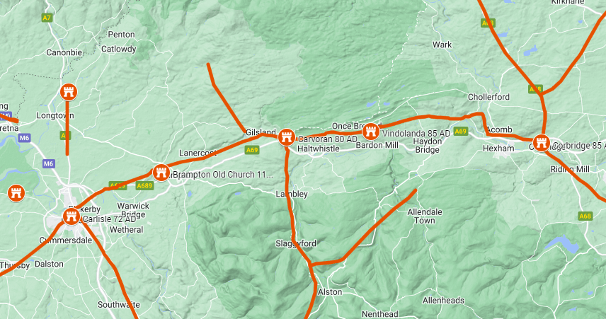
The Stanegate was an east–west Roman road linking Corbridge, on the River Tyne, with Carlisle. It ran south of the line later taken by Hadrian’s Wall, connecting military bases and the major routes leading north and south. Its importance lies both in moving soldiers and supplies and in the development of Rome’s northern frontier.
A road before the Wall
The road belongs to the Roman military expansion of the later first century AD. It is often associated with Agricola’s campaigns, but attributing its construction to Agricola alone is more certain than the evidence allows. The forts and road system developed over time: Carlisle’s first fort dates to around AD 72–73, while the fort at Corbridge was established around AD 86, replacing an earlier base nearby.
Vindolanda was another important base along the route. Its first fort pre-dated Hadrian’s Wall by almost forty years. The Vindolanda Trust explains how Vindolanda, Magna (Carvoran) and Corbridge were subsequently incorporated into the Wall’s wider defensive system.
Was the Stanegate a frontier?
After the Roman army withdrew from much of Scotland, the forts along the Stanegate became an important concentration of troops. The term “Stanegate frontier” is commonly used for the arrangement before work began on Hadrian’s Wall in AD 122. Forts, smaller posts and towers could support patrols, communication and the supervision of movement.
However, this was not a continuous barrier like the later Wall. Archaeologists debate how far the installations formed a deliberately organised frontier and how far they protected a strategically important road and its supplies. The dating and distribution of the smaller posts leave uncertainties. Nicholas Hodgson’s “The Stanegate: a Frontier Rehabilitated” (Britannia 31, 2000, pp. 11–22) argues for the frontier interpretation; the discussion in Protecting the Roman Empire explores the competing explanations.
Hadrian’s Wall and the connection with Scotland
The construction of Hadrian’s Wall changed the Stanegate’s role, but did not make the road redundant. It remained a route behind the new frontier. At Corbridge it connected with Dere Street, the major road north into what is now Scotland.
English Heritage’s history of Corbridge describes renewed building activity in AD 139–140 associated with its role as a supply centre for the advance under Antoninus Pius. This makes the Stanegate part of the wider story of Roman roads in Scotland: campaigns north of the border depended on communications and bases further south.
At Corbridge today, visitors can walk along the surviving Roman main street forming part of the Stanegate. It offers a useful reminder that a military road could also become a busy street within a developing town.
Related Posts
- Carlisle Roman Fort — The military base at the western end of the Stanegate.
- Hadrian’s Wall 122 AD — How the frontier developed after the Stanegate system.
- Roman Roads in Scotland — The wider network connecting forts and supporting campaigns.
References
- Stanegate (Wikipedia)
- The Stanegate Roman Road, Margary 85 (Roman Roads Association)
- Stanegate – Roman Britain (Roman Britain)
- The Stanegate – Tynedale Hadrian’s Wall Group
- Stanegate (Newcastle University)


Comments
One response to “The Stanegate Road”
[…] Explore the Stanegate Road […]
LikeLike