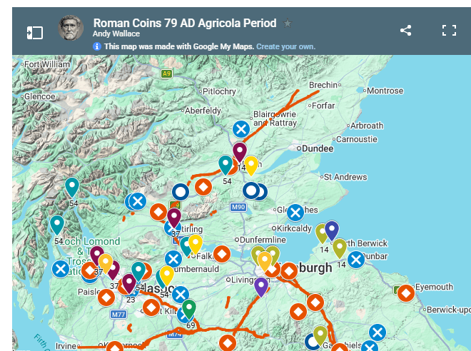
Explore the Roman presence in Scotland through maps.
Roman Scotland makes much more sense when it is seen geographically. Forts follow roads and river valleys. Temporary camps reveal the routes taken by campaigning armies. The Antonine Wall crosses the narrowest part of central Scotland. Coin finds show patterns of contact and activity far beyond the military frontier.
This page brings together the many maps on Romans in Scotland, from simple visitor maps to more detailed archaeological and GIS-based resources.
🗺️ Start with the Interactive Map
Find Romans Near You
Want to know what Roman sites are near you?
The main interactive map brings together Roman forts, camps, roads, finds and museums across Scotland.
→ Explore: Find Romans Near You
This is the best map for visitors, families and anyone wanting to explore Roman Scotland on the ground.
Roman Military Sites
🏰 Roman Forts in Scotland
Roman forts formed the backbone of military occupation. They occur from the Borders and southern Scotland through the Central Belt and north into Perthshire.
The fort map allows you to explore sites across Scotland and identify surviving Roman sites close to you.
→ Explore: Roman Forts in Scotland
Many individual fort pages also contain more detailed maps showing roads, camps, annexes, bathhouses and nearby archaeological discoveries.
⛺ Roman Camps in Scotland
Temporary camps are particularly important because they can reveal the movement of Roman armies.
Unlike permanent forts, many survive only as cropmarks, earthworks or features detected by aerial photography and geophysical survey.
The map is based largely on recorded archaeological sites in the Historic Environment Scotland Canmore database.
→ Explore: Roman Camps in Scotland
Follow the Roman Army Through Time
⏳ Romans in Scotland – Maps Through the Years
Roman control of Scotland was never continuous.
This collection of maps follows the changing military landscape over more than two centuries, including:
- the invasion associated with Agricola
- the withdrawal from Scotland
- the creation of Hadrian’s Wall
- the advance to the Antonine Wall
- later Roman activity north of Hadrian’s Wall
- the campaigns of Septimius Severus
Forts appear, disappear and are sometimes reoccupied during different periods.
→ Explore: Romans in Scotland in Maps Through the Years
Key campaign maps
AD 79–84 – Agricola’s campaigns
Maps show forts, roads and coin finds associated with the first major Roman advance into Scotland.
→ Explore: Agricola 79 AD Invasion
AD 142 onwards – The Antonine occupation
Explore the Antonine Wall, its forts and the wider military network created when Rome moved its frontier northwards.
→ Explore: The Antonine Wall 142 AD
AD 208–211 – Septimius Severus
Maps illustrate the evidence associated with the last major imperial campaign deep into Scotland.
→ Explore: Septimius Severus 208 AD Invasion
The Roman Frontiers
🧱 The Antonine Wall
The Antonine Wall was much more than a single barrier.
Mapping reveals a complex military landscape containing:
- the Wall rampart
- monumental ditch
- Military Way
- forts
- fortlets
- temporary camps
- annexes
- bathhouses
- civilian activity
- distance slabs and inscriptions
Maps on the website allow individual sectors and forts to be examined in greater detail.
The distribution of the surviving Antonine Wall Distance Slabs can also be explored alongside the sections of Wall constructed by the three legions.
→ Explore: Antonine Wall Distance Slabs
Roman Roads
🛣️ Roads Across Scotland
Roads linked forts, ports, supply bases and frontiers.
Mapping them helps explain why Roman military sites occur where they do and how troops and supplies moved through Scotland.
Some routes remained important long after the Roman army had gone and have influenced later roads and settlement patterns.
→ Explore: Roman Roads in Scotland
Individual site pages often show the relationship between a fort and the Roman road network.
The Gask Ridge
👁️ Forts, Fortlets and Watchtowers
North of the Central Belt is one of the most intriguing Roman military landscapes in Britain.
The Gask Ridge contains a chain of forts, fortlets and watchtowers associated with Roman activity north of the later Antonine frontier.
Mapping the sites makes their relationship to the Roman road and surrounding landscape much easier to understand.
→ Explore: Roman Gask Ridge Watchtowers
Several stretches can also be explored on foot or by bicycle.
Coins and Archaeological Finds
🪙 Roman Coin Maps
Coins provide a very different map of Roman Scotland.
The website contains maps showing:
- coins by emperor
- coins by date
- coin hoards
- Flavian/Agricolan-period coins
- Antonine-period coins
- later second-century finds
- Severan and later Roman finds
A note of caution
A Roman coin found in Scotland does not necessarily mean that a Roman soldier stood at that location.
Coins could move through:
- trade
- diplomatic payments
- gifts
- movement between communities
- later collecting
- redeposited soil
- accidental loss in much later periods
Individual finds therefore need to be interpreted carefully. Patterns involving many finds are generally more informative than isolated discoveries.
Roman Coin Hoards
Hoards can sometimes provide another view of relations between Rome and communities beyond the frontier.
Maps on the site divide known hoards into different chronological periods so geographical patterns can be compared.
Their interpretation remains uncertain: a hoard might represent buried savings, military activity, trade, political payments or completely different circumstances.
Rivers, Valleys and Landscape
🌊 Why Were Roman Forts Built Where They Were?
Roman military geography was strongly influenced by the landscape.
Maps can reveal relationships between:
- forts
- rivers
- valleys
- roads
- natural routeways
- coastlines
- harbours
- mountain passes
Large military sites needed water, communications and reliable supply routes.
Looking at Roman sites against the physical landscape can therefore explain patterns that are much less obvious from a list of archaeological sites.
Several individual fort pages contain maps examining these relationships.
→ Explore Romans, Rivers and Valleys
Local and Site Maps
Some of the most useful maps on Romans in Scotland are found inside individual site articles.
These can show archaeology that is no longer visible on the ground.
For example, maps may identify:
- fort ramparts
- defensive ditches
- annexes
- bathhouses
- aqueducts
- roads
- harbours
- temporary camps
- civilian settlement
- altars and inscriptions
- possible amphitheatres
Inveresk Roman Fort, for example, can be viewed as part of a wider landscape containing its fort, roads, harbour, aqueduct and important archaeological discoveries.
When reading an individual site article, look for maps and aerial images within the page.
Museums and Roman Finds
🏛️ Where Did the Archaeology Go?
The archaeological site is often only half the story.
Many of Scotland’s most important Roman objects are now preserved in museums rather than at the place where they were discovered.
Museum mapping helps connect:
the archaeological site → the discovery → the object → the museum where it can now be seen.
This is particularly useful when planning a Roman Scotland visit.
Ancient Maps
📜 How Did the Romans Map Their World?
Roman maps were very different from modern geographical maps.
The Tabula Peutingeriana, or Peutinger Table, survives in a medieval copy of an ancient Roman route map. Rather than accurately representing geography, it emphasises roads, settlements and connections across the Empire.
→ Explore: Peutinger Table – Ancient Roman Road Map
It provides a fascinating comparison with today’s digital mapping and GIS.
GIS and Modern Archaeology
What is GIS?
GIS – Geographic Information Systems – allows archaeological information to be attached to geographical locations and different sets of evidence to be compared as map layers.
For Roman Scotland, this can include:
- known archaeological sites
- excavation results
- Roman roads
- inscriptions
- coin finds
- elevation
- rivers and coastlines
- aerial photographs
- historical maps
- LiDAR
- geophysical survey
Instead of studying each piece of evidence separately, GIS allows relationships and geographical patterns to be investigated.
LiDAR
LiDAR uses laser scanning to measure the ground surface extremely accurately.
Digital terrain models can reveal slight banks, ditches, roads and other features which may be difficult to see at ground level.
It has become particularly useful for investigating parts of the Antonine Wall and other Roman landscapes.
Geophysical Survey
Archaeologists can also investigate what lies beneath the ground without excavation.
Techniques include:
- magnetometry
- electrical resistance survey
- ground-penetrating radar
- electromagnetic survey
These methods have transformed our understanding of some Roman forts and sections of the Antonine Wall.
Mapping the results allows buried buildings, ditches, roads and other archaeological features to be placed within the wider Roman landscape.
Mapping Sources
Maps on Romans in Scotland draw on a range of archaeological and historical sources.
Important resources include:
Historic Environment Scotland – Canmore
Scotland’s national record of archaeological sites, monuments, buildings and discoveries.
National Library of Scotland Maps
Historic Ordnance Survey and earlier maps are invaluable for identifying sites before modern development altered the landscape.
Roman Inscriptions of Britain – RIB
The locations of inscriptions can help identify military units, individuals, religious activity and building programmes.
Archaeological excavation reports
Detailed plans produced by excavations provide some of the most reliable evidence for individual forts and settlements.
Aerial photography and LiDAR
These are particularly valuable where Roman remains survive beneath modern farmland or development.
Academic research
Dating and interpretation frequently change as new excavations, geophysical surveys and research are published.
Maps Are Evidence — Not Certainty
Roman archaeology is constantly developing.
Locations shown on maps may have different levels of certainty. Some forts have been extensively excavated; others are known mainly from cropmarks or geophysical evidence. The precise routes of some Roman roads remain debated.
Dates can also change when new evidence becomes available.
For that reason, the maps on Romans in Scotland should be used as guides to the archaeological evidence rather than as a claim that every boundary, road or date can be known precisely.
Where possible, individual articles link back to excavation reports, Canmore records, inscriptions and academic research so that the evidence can be examined directly.
Explore Roman Scotland
🗺️ Find a Roman site near you
🏰 Explore forts
⛺ Explore temporary camps
🛣️ Follow the roads
🧱 Explore the frontier
👁️ Explore the Gask Ridge
→ Roman Gask Ridge Watchtowers
🪙 Follow the archaeological evidence
⏳ Watch Roman Scotland change over time
→ Romans in Scotland in Maps Through the Years
More Maps
New maps are regularly added as individual sites and subjects are researched.
Together these maps help reconstruct something increasingly difficult to appreciate from individual ruins alone: the enormous military landscape created by Rome’s repeated attempts to conquer, occupy and control northern Britain.

