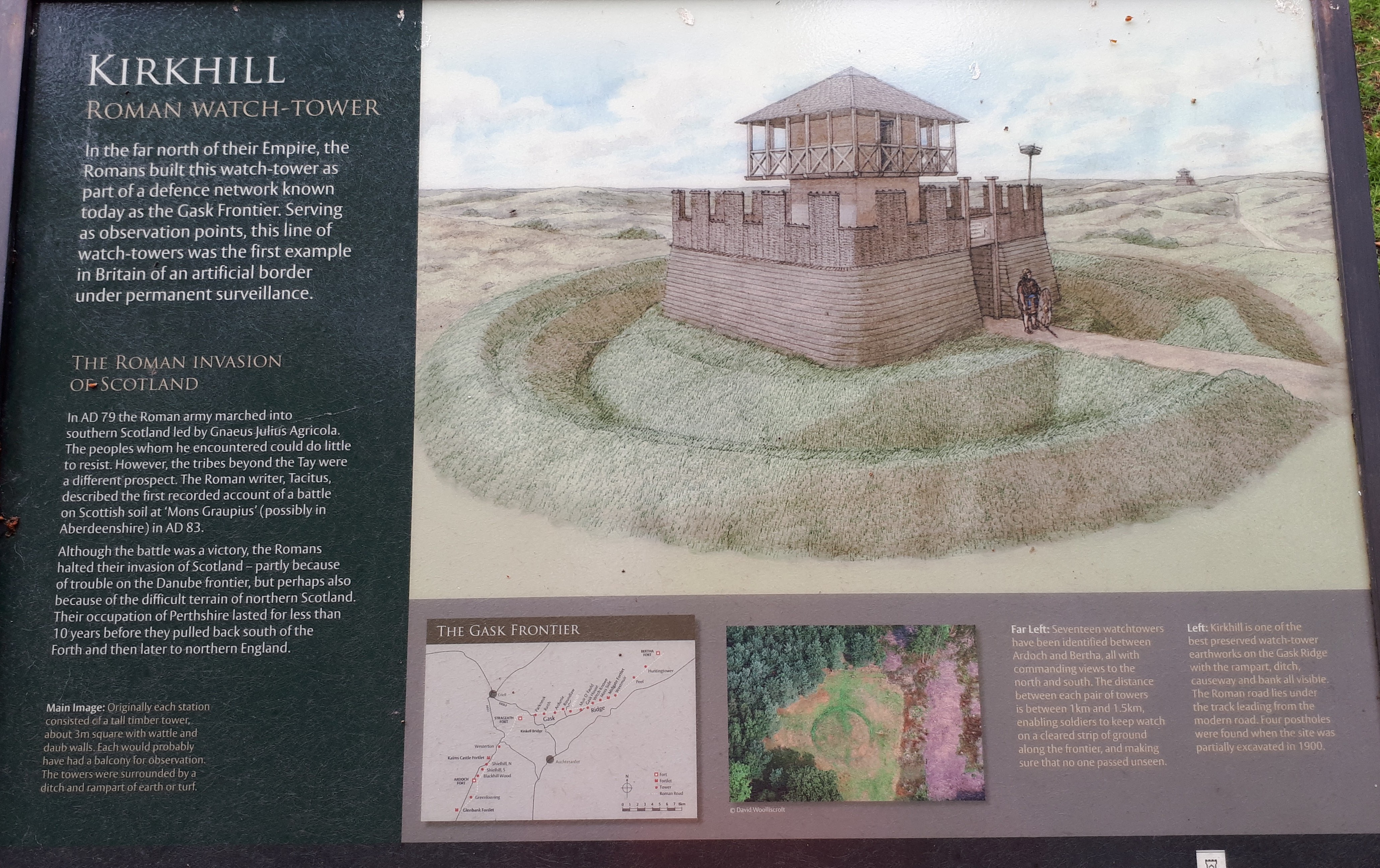
Kirkhill lies south of the Roman road, between Roundlaw and Muir o' Fauld. The surviving earthworks mark a much larger enclosure than the small timber building that once stood inside. Keeping those two scales separate makes the site easier to understand on the ground.
Visit Kirkhill
📍 Location: Kirkhill, Perth and Kinross. National Grid reference NN 9676 1883.
👁 What survives: A surviving earthwork enclosure in woodland; the timber tower has gone.
⭐ Best for: A woodland earthwork beside the Gask road.
🥾 Visit: The pin marks the archaeological site, not a parking place, entrance or confirmed walking route. Use existing appropriate paths, respect crops and neighbouring homes, and follow local signs and any forestry restrictions.
🏛 Explore nearby: Gask Ridge watchtower guide · Strageath Roman Fort
Google Map location · Trove site record · HES scheduled monument record · Roman Gask Project
Approximate site pin, converted from the published National Grid reference (OSGB36 / British National Grid) to WGS84. Use it to locate the site, not its scheduled boundary. The reference is shown at approximately 10 metres precision; it is not a new survey.
Kirkhill at a glance
| Feature | Evidence and interpretation |
|---|---|
| Period | Usually assigned to the late first-century, Flavian Gask system; precise site chronology remains uncertain. |
| Remains | A surviving earthwork enclosure in woodland; the timber tower has gone. |
| Roadside position | South of the Roman road. |
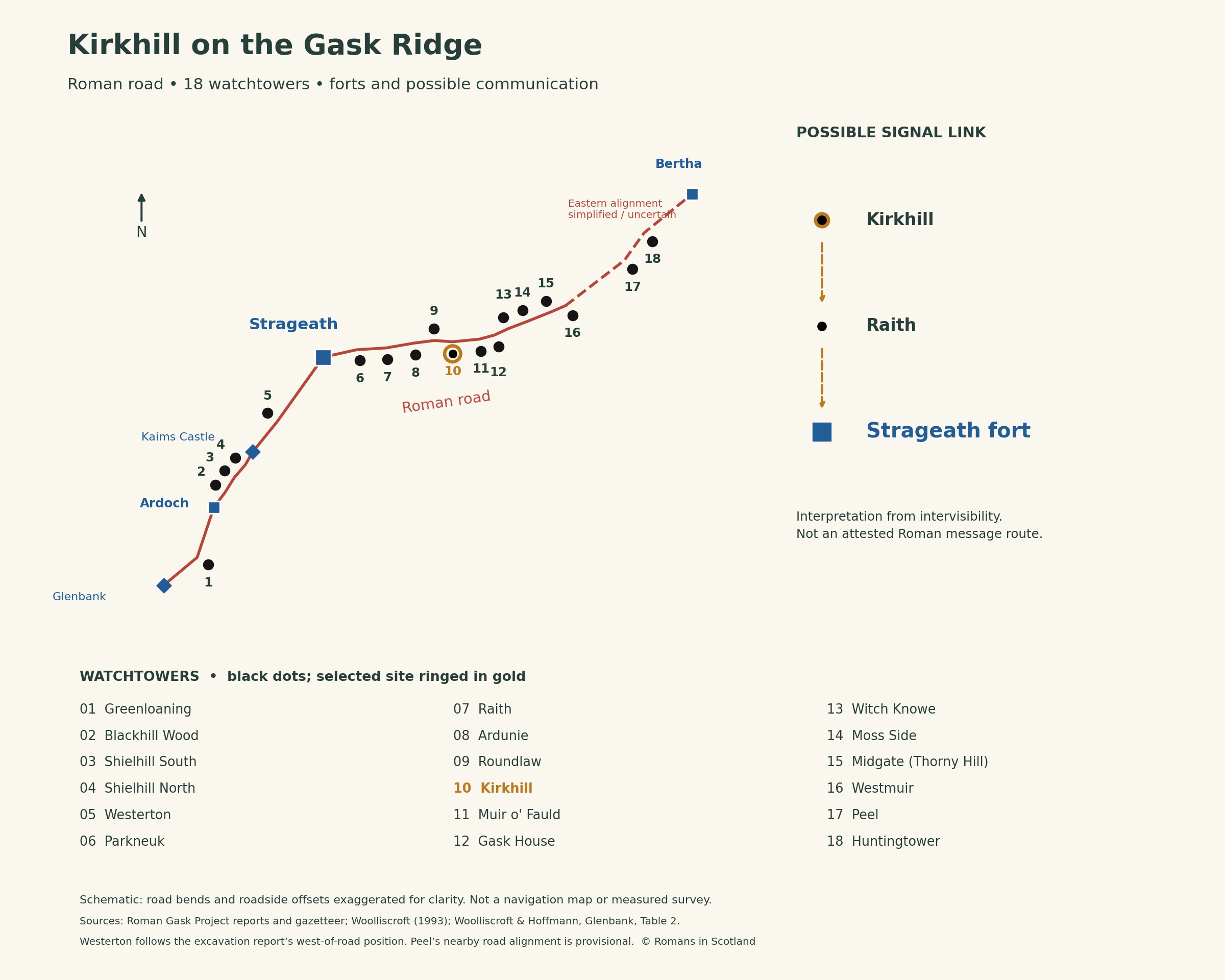
| Possible communication | Kirkhill → Raith → Strageath |
| Garrison | The unit and number of soldiers are not securely known. |
The remains and their investigation
Christison's investigation in 1900 recorded a level interior, a surrounding ditch and an outer mound formed from excavated material. He gave an overall width of 112 feet, about 34 metres, including the outer bank. This is not the width of the tower. Four central post holes outlined a square about 9 feet 6 inches, or 2.9 metres, across.
The same report described the ditch as approximately 4 feet deep and the outer mound as standing about 2 feet above the surrounding ground. These are historical excavation observations, not a guarantee of what can be measured today. Woodland growth, weathering and later work affect the appearance and visibility of the remains.
Kirkhill belongs to the single-ditched group on the ridge proper. Its early excavation establishes the timber post arrangement, but provides much less information about the building above ground or a tightly dated occupation sequence. A late first-century date is normally proposed from its relationship with the Gask system; the soldiers' unit and daily routine remain unknown.
Watching the road
The nearby road linked the larger garrisons and the smaller posts. A watchtower gave soldiers an elevated position from which to observe traffic and the surrounding ground. The close spacing of these installations makes sense for surveillance as well as communication: recognising movement on a road is a different task from seeing a distant warning signal.
Modern trees, field boundaries and road surfaces are later parts of this landscape. They can hide both the earthworks and former sightlines. A modern ground-level view should therefore be compared cautiously with the possible outlook from a timber platform.
Kirkhill on the Gask Ridge
Possible communication with the forts
In Woolliscroft’s proposed network, the ridge-top towers as far east as Midgate could communicate with Raith. Raith could then relay a signal to Strageath. The diagram shows this possible two-stage connection for Kirkhill; it does not claim a demonstrated direct view to the fort.
These links depend on assumptions about tower height and visibility. Vegetation, weather and whether the installations were occupied at the same time also matter. Neither the diagram nor the surviving earthworks establishes a signalling code, a fixed watch rota or the size of a tower crew.
References and further reading
Trove: Kirkhill — NRHE 25988 — national site record, location and archaeological references.
HES scheduled monument record — SM90332. HES designation records are available through Trove.
Christison (1901): Kirkhill, report of the 1900 excavation — report or source text hosted by the Roman Gask Project.
Woolliscroft (1993), Signalling and the design of the Gask Ridge system, PSAS 123, 291–313 — possible links and their limitations.
Woolliscroft and Hoffmann, The Roman Gask system fortlet of Glenbank, PSAS 139, 167–193, Table 2 — comparative roadside positions. Westerton follows its excavation report where the descriptions differ.
Read alongside the Gask Ridge watchtower guide and the guide to Roman forts in Scotland.

