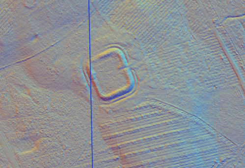
Castle Greg is small enough for its military scale to be grasped at a glance. Its banks and ditches enclose a compact post on Camilty Hill, but the visible outline tells us more than the surviving evidence for its dates or garrison.
Visit Castle Greg
📍 Location: Camilty Hill, near Harburn and West Calder, West Lothian. Grid reference NT 050 593.
👁 What survives: Grass-covered rampart and ditch earthworks.
⭐ Best for: Seeing the compact scale of a Roman fortlet on the ground.
🥾 Visit: Rough, sometimes wet upland ground. Use suitable footwear and take care around the earthworks and livestock.
🏛 Nearby Roman places: The Roman routes across the Lothians; Cramond and the Antonine Wall provide wider comparisons.
Castle Greg at a glance
| Feature | Evidence and interpretation |
|---|---|
| Occupation | Roman, but not securely dated within the first or second century AD. Older coin reports do not establish a precise occupation span. |
| Garrison | An unidentified small detachment. |
| Size | Approximately 54 × 46 m: 0.25 hectares (0.61 acres). |
| Probable troop strength | Perhaps 80–100 troops as a size-based estimate; the actual establishment is unknown. |
A compact defended enclosure
The fortlet has rounded corners, double ditches and an entrance on the east. A trace of an approach road has also been recorded. Its roughly quarter-hectare footprint places it among the small installations that could support movement between larger bases.
Why the date remains uncertain
Antiquarian accounts describe coins and other discoveries, including material attributed to different Roman periods. Without secure excavated contexts, those reports cannot establish that the fortlet was occupied throughout that span. A precise opening year, closing year or named imperial campaign would exceed the available evidence.
A small party of soldiers
The supplied area estimate rounds to about 90 men, best presented as approximately 80–100. This might represent a detached party from a larger unit, but the fort’s size is not a preserved order of battle. The usable interior was smaller than the enclosing rectangle, and stores or animals would also require room. Guarding movement and relaying messages are plausible functions for a post of this scale, not documented assignments.
Inscriptions and the identity of the troops
No securely attributable inscription naming Castle Greg’s soldiers has been established in the consulted records. RIB offers regional comparisons, but no named cohort or cavalry regiment should be assigned here without new evidence.
For the regiments and types of troops represented across Scotland, see Auxiliary units in Roman Scotland. The Roman Army guide explains the wider organisation, while Roman fort layout introduces the buildings found in permanent bases.
References and further reading
- Historic Environment Scotland: Castle Greg, NRHE 48988 — site record, archaeological notes and excavation bibliography.
- Historic Environment Scotland: Castle Greg Roman fort, SM1933
- Romans in Scotland fort-size spreadsheet — supplied copy used for dimensions and rounded capacity estimates, with archaeological measurements preferred where revised.
- Paul Holder (2003), ‘Auxiliary Deployment in the Reign of Hadrian’, especially p. 120 — nominal unit organisation, consulted in the supplied PDF; not a local garrison identification.

