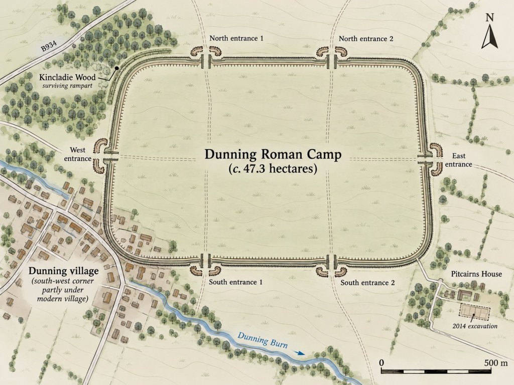
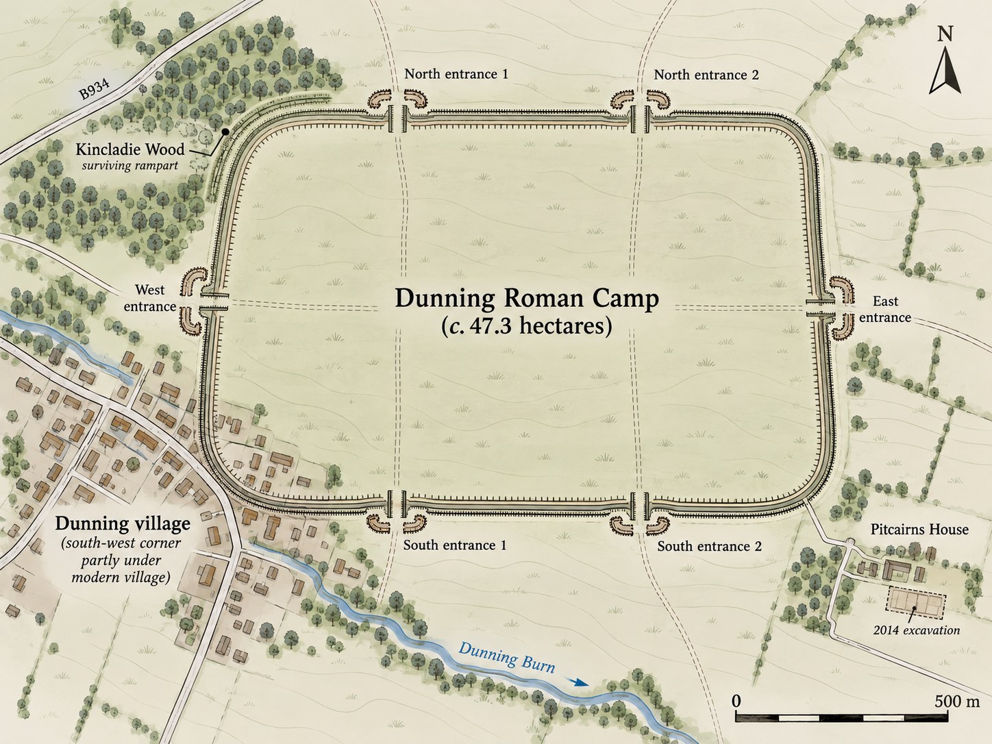
The remains of a large Roman camp lie beneath the fields north-east of Dunning, in Perthshire. Its south-west corner is now covered by part of the village, and most of the defensive earthworks disappeared during agricultural improvements. About 130 metres of bank still survive in Kincladie Wood, beside the B934. Otherwise, the camp is known largely from marks seen in crops from the air.
At some 47 hectares (117 acres), Dunning was big enough to accommodate a legion of around 5,000 men, though that does not tell us how many soldiers actually stayed there. It had six entrances: two on the north side, two on the south, and one each on the east and west. The 2014 excavation helped confirm the southern entrance positions. This arrangement also occurs at other Scottish camps, including Raedykes and Normandykes; see Roman marching camps with six gates. Dunning has also been compared in size and layout with the camp at Carey, near Abernethy.
Where was the camp?


The pin shows the approximate location of Dunning Roman Camp, not the surviving line of its defences. For details of the protected archaeological site, see Historic Environment Scotland’s scheduled monument record.
What the excavations found
In the summer of 2014, the University of Glasgow’s Strathearn Environs and Royal Forteviot (SERF) project examined the camp at two places. One excavation crossed the surviving bank and ditch in Kincladie Wood, near a northern entrance. The other was at Pitcairns House on the south-eastern side, where the route of the defences was uncertain. This work followed the discovery of Roman material at the nearby Castle Craig broch, which had brought renewed attention to the Roman presence in the district.
The northern trench exposed a V-shaped ditch 3.1 metres wide and 1.75 metres deep, with a narrow slot cut into its bottom. Beside it was the remains of a turf and earth rampart, separated from the ditch by a strip of open ground. A slot on the inner side probably held timber supporting the rampart. The excavators also noted possible traces of a palisade, although that identification was less secure.
At Pitcairns House, the team found the southern ditch where earlier geophysical survey had failed to locate it. The line of the ditch helped confirm the position of the entrances on this side of the camp. It was another substantial Roman defensive work, in places about two metres deep.
Evidence that the Romans came back
The most important finding was not the size of the defences but their history. The original ditch had been allowed to fill naturally with soil. Later, another ditch had been cut into it. This sequence appeared at both 2014 excavation areas and matched evidence from earlier investigations on other sides of the camp.
It therefore looks as though a sizeable Roman force returned and reused the whole enclosure, rather than occupying a small corner of an abandoned camp. The silt that accumulated in the first ditch suggests the interval between the two phases was appreciably longer than a single campaigning season. Just how much longer remains unknown.
A temporary camp in name only?
Roman marching camps were often occupied briefly, but the defences at Dunning seem unusually carefully made. The probable timber support behind the rampart, the substantial ditch and the evidence for renewed occupation led the excavators to question whether the usual description of the site as a ‘temporary camp’ tells the whole story.
They suggested that Dunning might have been used for a more sustained military undertaking, perhaps connected with the building of the Gask Ridge military system or operations associated with the legionary fortress at Carpow. These are possibilities, not secure identifications. No Roman coins or pottery were recovered from the excavated defences to date either occupation. Charcoal found beneath the rampart offered the prospect of radiocarbon dating, but this report did not establish a construction date.
Dunning has also been mentioned in discussions about Agricola and the Battle of Mons Graupius, partly because of the nearby place-name Duncrub. The report regards that place-name argument as doubtful. The camp shows that a large Roman force operated in Strathearn; it does not tell us where Agricola fought his battle.
The work leaves some important questions open, particularly how the camp related to the local communities of Strathearn. Excavation within the enclosure, rather than only across its defences, might eventually help to answer them. For now, Dunning is a useful warning against assuming that every Roman ‘temporary camp’ had a short or simple history.
The excavation report
Ewan Campbell, Joss Durnan and Stephen Driscoll, Excavations at Dunning Roman Camp: Data Structure Report (University of Glasgow, 2014). The full 43-page report is available as a PDF, with site plans, sections and excavation photographs. Figure 2 shows the camp’s outline as reconstructed from aerial photographs.
Related reading: Inside a Roman Marching Camp and Roman Camps in Scotland.

