At Ardunie, a low grassy platform and a surrounding ditch mark the site of a Roman watchtower beside the road along the Gask Ridge. There is no standing tower today. Its importance becomes clearer when it is placed among the neighbouring posts: a small lookout here formed part of a much wider military presence across Strathearn.
Visit Ardunie
📍 Location: Near Trinity Gask, north of Auchterarder, Perth and Kinross. National Grid reference NN 9469 1876.
👁 What survives: The platform and surrounding earthworks; the timber superstructure has disappeared.
⭐ Best for: Understanding the small scale of a watchtower site and its relationship with the Roman road.
🥾 Visit: HES lists the site as open all year. Check its visitor information before travelling. The location marker identifies the archaeological site, not a car park or vehicle entrance.
🏛 Nearby Roman places: Raith and Roundlaw watchtower sites, and Strageath Roman Fort.
🗺 Open Ardunie in Google Maps · Trove archaeological record · HES visitor page · Roman Gask Project gazetteer
Map marker: Trove’s recorded location, accurate to the nearest 10 metres. It does not show the monument boundary.
Ardunie at a glance
| Feature | Evidence and interpretation |
|---|---|
| Date | Generally assigned to the late first century AD, in the Flavian period. Exact construction and abandonment dates are unproven. |
| Type | A small timber watchtower inferred from its earthworks and comparison with excavated Gask sites. |
| Surviving platform | Approximately 14.4 m across in the HES description; this is not the width of the timber tower. |
| Investigation | Recorded by O. G. S. Crawford in 1937 and surveyed by the Ordnance Survey in 1967. HES’s Statement of Significance describes it as unexcavated. |
| Possible communication | Strageath fort via a relay at Raith, following Woolliscroft’s intervisibility interpretation. |
| Soldiers | The unit and number of men stationed here are unknown. |
Beside the Roman road
The tower site lies about 10 metres south of the Roman road. HES describes a causeway linking the enclosure with it, a ditch about 2.4 metres wide and surviving to around 0.4 metres deep, and a slight outer earthwork. These are measurements of the surviving remains, rather than the original depth or height of the defences.
Comparison with excavated towers suggests a square timber structure within the enclosure. Ardunie itself does not supply an excavated ground plan from which to reconstruct its upper floors, roof or height. A drawing of a complete tower would therefore be an interpretation, not a record of a building found here.
Where Ardunie fits on the Gask Ridge
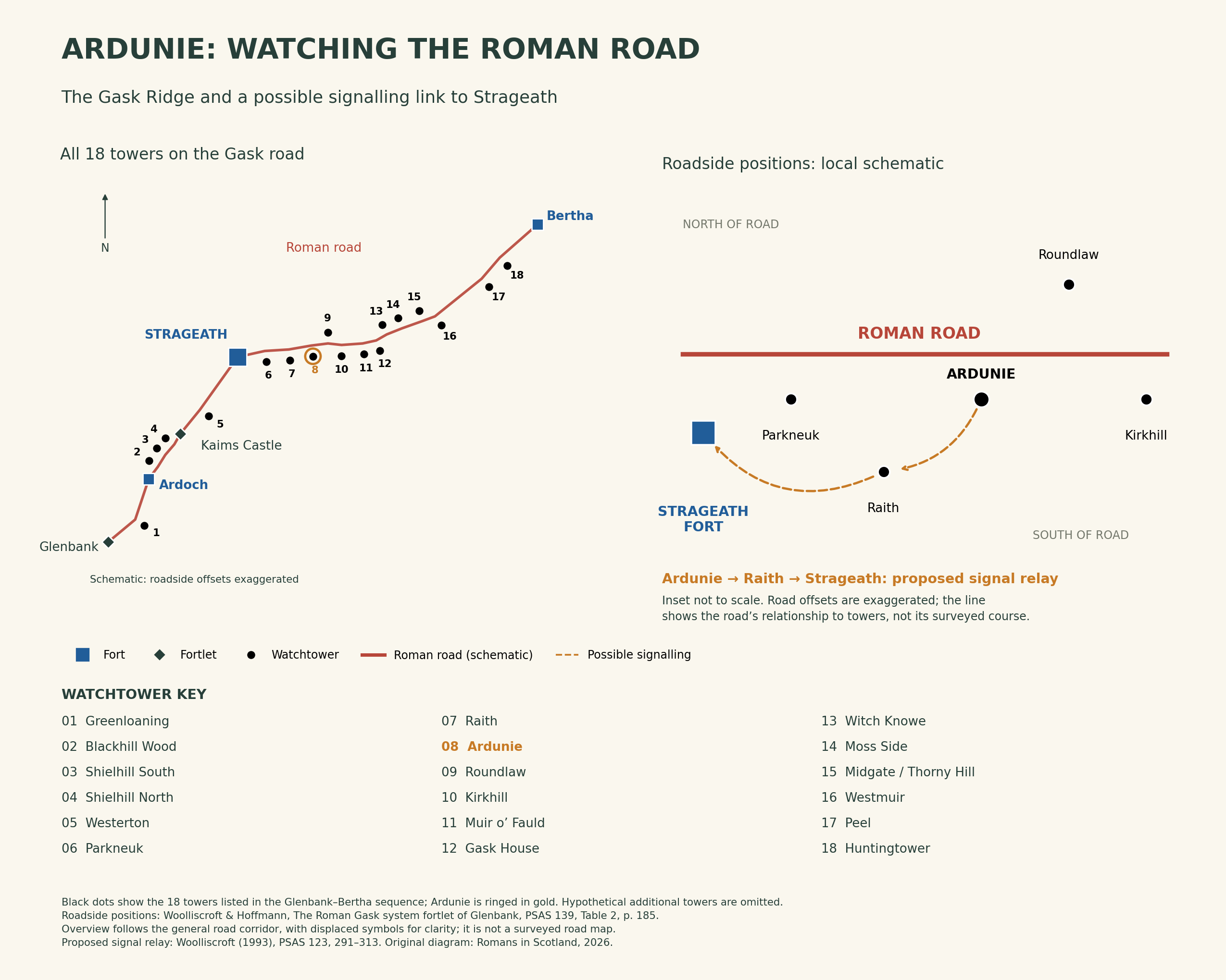
Ardunie stands between Raith to the west and Roundlaw to the east. The overview now includes all 18 towers listed along the Glenbank–Bertha road sequence in Woolliscroft and Hoffmann’s Glenbank report, Table 2. Black dots show their recorded sides of the road, with offsets enlarged for readability rather than drawn to scale. The local inset explains Ardunie’s possible signalling connection to Strageath via Raith. Hypothetical additional towers are not plotted.
Which fort could it communicate with?
David Woolliscroft’s study of signalling and the design of the Gask system offers a specific answer: Strageath, through Raith. In his analysis, Raith could see both the fort and the ridge-top towers further east, making it a potential relay for Ardunie.
This is a proposed arrangement based on lines of sight, not direct evidence that a particular signal was sent. Tower heights, vegetation, weather and whether the installations were occupied together all affect the interpretation. The dashed arrows on the diagram identify that distinction.
Watching the road and surrounding country may have occupied more of the soldiers’ time than signalling. Communication would let an observation post pass information to a larger garrison; it does not require us to imagine a continuous chain of messages travelling through every neighbouring tower.
What remains uncertain
The late-first-century attribution places Ardunie within the period of Rome’s first major occupation of this part of Scotland. It does not give the tower a securely established foundation year. HES explicitly identifies its precise date, duration of use and architectural form as gaps in knowledge.
The distinction matters here because the site is unexcavated in the HES account. Details established at another Gask tower cannot simply be transferred to Ardunie. Its surviving earthworks are valuable evidence, but they leave much of the building’s history unresolved.
References and further reading
Trove: Ardunie, NRHE 26019 — location, survey history and bibliography.
Historic Environment Scotland: Ardunie Roman Signal Station — official visitor information.
HES: Ardunie Statement of Significance — earthwork description and research gaps; document last reviewed in 2005. Information reused under the Open Government Licence v3.0.
Roman Gask Project: Gazetteer — Ardunie and the surrounding sites.
Woolliscroft, D. J. (1993), ‘Signalling and the design of the Gask Ridge system’, Proceedings of the Society of Antiquaries of Scotland 123, 291–313 — the basis of the proposed relay shown here. Read alongside its stated assumptions.
← Explore the Gask Ridge frontier · Strageath Roman Fort · Guide to Roman forts in Scotland

