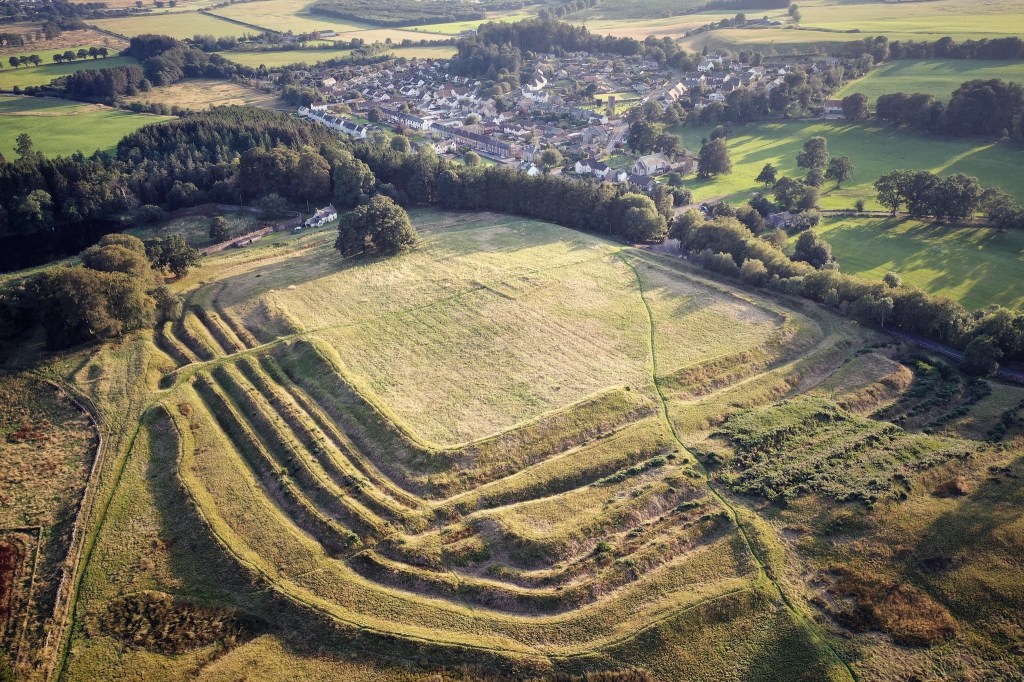
Just north-east of Braco, Ardoch Roman Fort offers something rare in Scotland: Roman defences that still make an immediate impression on the ground. Ranks of grassy banks and ditches surround the interior, revealing the scale of the army’s work long after its buildings disappeared.
Visit Ardoch Roman Fort
📍 Location: Braco, Perth and Kinross · Grid reference NN 839 099
👁 What survives: Impressive grass-covered ramparts and ditches around the fort.
⭐ Best for: Seeing Roman earthwork defences and understanding how a fort changed over time.
🥾 Visit: Uneven grass, steep banks and deep ditches; wear sturdy footwear and follow local access notices.
🏛 Nearby Roman places: Black Hill Roman Camps, Kaims Castle and the Gask Ridge
Ardoch belongs to the wider Gask military landscape. Its story spans repeated Roman advances and withdrawals, with a permanent fort, temporary camps, a road and a watchtower forming a much larger complex.
Watch: a tour of Ardoch
Site visit · History Hit
Take a video tour of Ardoch to see the fort’s earthworks and their setting in the landscape.
Ardoch at a glance
| Occupation | Flavian occupation followed by two principal Antonine phases. |
| Garrison | The First Cohort of Spaniards is named on Ammonius’s tombstone. |
| Size | Latest fort about 5.7 acres (2.3 hectares); earlier enclosures and surrounding camps were larger. |
| Troop estimate | The changing plan and possible detached personnel prevent a single reliable headcount. |
Inscriptions
RIB 2213 commemorates Ammonius, son of Damio, a centurion of the First Cohort of Spaniards with 27 years of service.
Sources for this summary
A fort on the route north
Ardoch stood beside the Roman route linking Camelon with the Tay. Its position helped connect the forts, fortlets and towers of the Gask system. Scholars debate how far this network functioned as a frontier or as protection for movement and supply.
The earliest fort belongs to the Flavian occupation of Scotland in the late first century. It was abandoned before the army returned during the Antonine period. Exact foundation and abandonment years should be treated cautiously: the archaeology gives a sequence more securely than a year-by-year timetable.
Why are there so many ditches?
The visible defences represent successive layouts. The first fort was the largest; two later Antonine forts occupied progressively smaller areas. New defensive lines were added as the enclosure changed. Reading every bank as part of one construction would therefore give a misleading picture.
The northern and eastern defences survive particularly well. Elsewhere, cultivation and the modern road have reduced the remains. The changing outlines make Ardoch an unusually rewarding place to see how a Roman fort developed.
Inside the fort
Excavations in 1896–97 exposed long barrack buildings belonging to different periods. Later geophysical survey has helped trace buried structures without opening extensive trenches. The broad grassy interior once contained a working military base, with accommodation and the daily business of the garrison.
Meet Ammonius: a soldier with a name
A sandstone tombstone brings an individual into this landscape. It commemorates Ammonius, son of Damio, a centurion of the First Cohort of Spaniards, who had completed 27 years of service. His heirs arranged the memorial.
The stone is now in the Hunterian collections in Glasgow. Its discovery was recorded by 1672, and it appears to have been reused in a medieval chapel within the fort. The regiment’s name does not establish Ammonius’s birthplace: the inscription’s editors suggest that his name and parentage may indicate eastern origins.
Read the inscription and translation — RIB 2213
The camps beyond the fort
The surrounding enclosures show that this was also a place where larger forces gathered. Several overlapping temporary camps survive as earthworks or cropmarks, alongside the road and watchtower remains.
The nearby Black Hill camps are associated by Historic Environment Scotland with the early third-century campaigns of Septimius Severus. The precise dating of individual camps in the wider complex is less certain. They should not all be assigned to one year or campaign.
Explore Black Hill Roman Camps — Historic Environment Scotland
What can you see today?
- The impressive banks and ditches, especially along the northern and eastern sides.
- The enclosed interior, where the garrison’s buildings once stood.
- Changes in the lines of the defences, reflecting successive phases.
The fort is on private land, with access generally allowed at reasonable times. Follow notices at the entrance, respect livestock and leave gates as you find them. Expect uneven grassy ground and steep ditch sides; check local conditions before planning a visit if mobility is limited.
Why Ardoch matters
Ardoch combines unusually legible earthworks with excavated evidence for successive garrisons. It lets visitors connect a fort’s changing shape with the wider history of Roman occupation—and, through Ammonius, with one of the people who served here.
Explore more
- Roman Forts in Scotland: Complete Guide
- Doune Roman Fort
- Roman Roads in Scotland
- Inside a Roman marching camp
- Explore Roman Sites
Archaeological records for the wider Ardoch complex
The following legacy Canmore references identify individual components of the complex. Acreages are traditional record labels.
- NN80NW 32 NN 8425 0999 Fort (Formerly entered as Temporary Camp)
- NN81SW 7 NN 8452 1075 Watch Tower (Scheduled as Signal Station)
- NN81SW 15 NN 8390 1090 Temporary Camp (’63 acre’)
- NN81SW 16 NN 8370 1060 Temporary Camp (’30 acre’)
- NN81SW 17 NN 8380 1050 Temporary Camp (’13 acre’: within NN81SW 16)
- NN81SW 18 NN 8420 1080 Temporary Camp (‘120 acre’)
- NN81SW 19 NN 8404 1022 Temporary Camp (Scheduled as Annexe to Fort NN80NW 10)
- NN81SW 40 Camelon – Ardoch – Strageath – Cargilll Roman road (RR 9a) [Scheduled length from NN 8425 1034 to NN 8486 1127]
Sources and further reading
- Historic Environment Scotland — Ardoch scheduled monument record (SM1601)
- Scottish Archaeological Research Framework — The Gask Ridge: Ardoch Roman Fort
- Scottish Archaeological Research Framework — Auxiliary forts
- Roman Inscriptions of Britain — Ammonius’s tombstone (RIB 2213)
- Historic Environment Scotland — Black Hill Roman Camps
- Trove — Ardoch archaeological record
The image “Ardoch” by spodzone is licensed under CC BY-NC-ND 2.0.

