At the entrance to the Sma’ Glen, Fendoch Roman Fort occupied a position where routes through the hills met the lowlands. Its remains are subtle today, but excavation has made it an important site for understanding Rome’s first occupation of northern Britain.
Visit Fendoch Roman Fort
📍 Location: Glenalmond, Perth and Kinross · Grid reference NN 9196 2830
👁 What survives: Slight earthworks and buried remains; much of the layout is known from excavation and survey.
⭐ Best for: Understanding the strategic landscape at the entrance to the Sma’ Glen.
🥾 Visit: A rural archaeological site; check access locally and respect fields, livestock and farm operations.
🏛 Nearby Roman places: The Fendoch signal station; Dalginross, Bertha and Ardoch in the wider region.
Fendoch at a glance
| Occupation | Flavian period, late first century AD; precise foundation and abandonment years remain uncertain. |
| Garrison | Unknown. |
| Size | About 2 hectares measured over the inner ditch in the later survey; the annexe is additional. |
| Troop estimate | The reconstructed barrack plan permits capacity estimates, but limited excavation makes a precise total uncertain. |
Inscriptions
No inscription securely naming the garrison is cited in the excavation and survey discussion.
Guarding the entrance to the glen
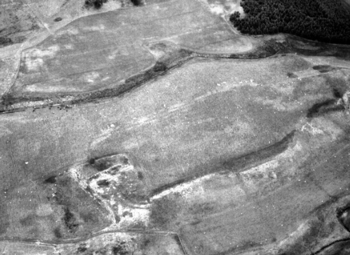
The fort stood on a glacial ridge near the meeting of the River Almond and Fendoch Burn. From here the army could observe routes towards the Sma’ Glen, Strathearn and the Tay. Fendoch belonged to the wider network of Flavian military sites along the Highland edge, associated with Agricola’s campaigns.
It is often described as a ‘glen-blocker’. This is a modern interpretation of its position, rather than a Roman name for its function. Monitoring movement, supporting communications and providing a base for troops are possibilities; the precise balance between these roles remains debated.
Inside the fort
Ian Richmond and James McIntyre’s excavations in the 1930s revealed a planned military interior. Their report identified the headquarters (principia), commander’s residence (praetorium), granaries, barracks and ovens, as well as examining the defences and a gateway. The elongated rectangular plan responded to the available ground.
These buildings help us imagine the daily routines behind the rampart: administering the unit, storing supplies, preparing food and housing soldiers. A particularly striking discovery was an intact sword in a foundation trench of the headquarters building.
Read the original excavation report — The Agricolan fort at Fendoch (1939)
How certain is the familiar plan?
Fendoch became an influential example of a Roman auxiliary fort, but the published reconstruction should be read with care. The Scottish Archaeological Research Framework notes that parts of its overall layout were inferred from limited excavation.
Recognising a barrack or granary in one trench does not establish every detail of the surrounding buildings. Nor does a reconstructed plan by itself prove the exact size or composition of the garrison. Later, more extensive excavations elsewhere have shown how much individual forts could differ.
The annexe and later survey
Geophysical survey reported in 2004 added important evidence beyond the excavated buildings. It traced a double ditch around the fort, distinctive entrance arrangements and an adjoining ditched annexe. The area measured over the inner ditch was approximately two hectares; this measurement should not be confused with the extent of the whole complex.
Survey also detected a possible roundhouse within the annexe and a separate anomaly tentatively suggested as a bath building. These remain interpretations: the archaeological record explicitly notes that the possible bathhouse has not been proved to be Roman, or even an artificial structure.
Explore the excavation and survey records on Trove
A planned departure
The excavators found evidence that the fort had been deliberately dismantled. This fits the wider withdrawal from northern positions in the later first century. Historic Environment Scotland suggests abandonment around AD 86–87, but the exact year is less secure than the evidence for an organised departure.
What can you see today?
Look for the shape of the ground and faint defensive traces rather than standing walls. A later farmstead also occupied the fort site, so visible features are not automatically Roman.
- Use the official site record and map to understand the fort’s position.
- Check access locally before entering fields; follow notices and respect crops, livestock and farm operations.
- The map button marks the site’s location, not a confirmed parking place or visitor entrance.
A separately scheduled Roman signal station survives nearby. Its archaeological record provides another way to explore the military landscape, although it should not be assumed to have a maintained visitor route.
Fendoch Roman signal station — official record
Why Fendoch matters
Fendoch is valuable both for what excavation revealed and for the questions it leaves open. Its short occupation offers evidence for the establishment and dismantling of a Roman base, while the history of research shows why familiar reconstruction plans still need to be tested.
Explore more
- Ardoch Roman Fort
- Doune Roman Fort
- Roman Forts in Scotland: Complete Guide
- Roman Roads in Scotland
- Explore Roman Sites
Sources and further reading
- Historic Environment Scotland — Fendoch fort and annexe (SM1603)
- Trove — Fendoch archaeological record
- Richmond and McIntyre (1939) — The Agricolan fort at Fendoch
- Scottish Archaeological Research Framework — Landscapes of occupation
- Scottish Archaeological Research Framework — Auxiliary forts
- Historic Environment Scotland — Fendoch signal station (SM4195)

