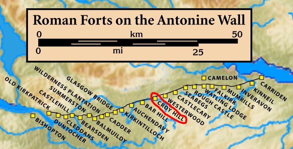
High above the Kelvin valley, Croy Hill preserves one of the most intriguing sections of the Antonine Wall. The fort itself has almost disappeared from view, but beneath and around the grass lie traces of a much more complicated Roman military landscape: a fort, a fortlet, an earlier enclosure or camp, a bath-house, a probable civilian settlement and the frontier works themselves.
Visit Croy Roman Fort
📍 Location: Croy Hill, North Lanarkshire
👁 What survives: The fort itself is difficult to see, but the Antonine Wall ditch, frontier earthworks and wider Roman landscape are clearly appreciable.
⭐ Best for: Walking a dramatic stretch of the Antonine Wall and seeing evidence for changes in the frontier’s design.
🥾 Visit: A hill walk on uneven grassy ground with slopes; conditions can be muddy.
🏛 Nearby Roman places: Bar Hill, Westerwood and Castlecary
Most importantly, Croy Hill provides evidence that the Romans did not simply arrive with one finished blueprint and build the frontier exactly as planned. The archaeology suggests that the design changed while construction was under way.
That makes this small fort one of the most useful places on the Antonine Wall for understanding how Rome’s northern frontier developed.
Watch: Croy Hill reconstructed
These digital interpretations show how the Roman site may have looked. They are reconstructions, rather than footage of surviving Roman buildings.
72 seconds · Reconstruction Model of Croy Hill Fort · Antonine Wall Vimeo Account
Reconstruction of Croy Hill Fort – Extended · 107 seconds
107 seconds · Reconstruction of Croy Hill Fort – Extended · Antonine Wall Vimeo Account
Croy Hill at a glance
| Occupation | Antonine period, broadly the AD 140s–160s; exact opening and closing years remain uncertain. |
| Garrison | Unknown; legionary building evidence is separate. |
| Size | About 0.6 hectares (1.5 acres) internally. |
| Troop estimate | A small detachment; the exact total is uncertain. |
Inscriptions
RIB 2161–2163 name the Sixth Legion in building work. The altar to the Nymphs is RIB 2160.
Sources for this summary
Hanson, Jones and Hannon (2024), Exploring the Antonine Wall with terrestrial remote sensing
A commanding position on the frontier
Croy Hill rises to around 120 metres above sea level and commands wide views across central Scotland. From the hill it is possible to look east towards the Forth and the hills of Fife, north towards the Kilsyth Hills and west towards Bar Hill, the next major Roman fort.
This was valuable military terrain. Observation, communication and control of movement were central to a Roman frontier system.
The Antonine Wall crosses the hill itself. Here the Roman builders faced the additional difficulty of basalt bedrock, and in places they had to cut the great frontier ditch through solid rock. The result is one of the most striking surviving landscapes anywhere on the Wall.
Two raised platforms or “expansions” survive on the western side of Croy Hill. They have often been interpreted as possible signalling or beacon platforms, although their precise purpose remains uncertain.
The fort was not the first Roman structure here
When Sir George Macdonald excavated Croy Hill in the 1920s and 1930s, he found another Roman enclosure beneath the later fort.
Macdonald interpreted this as an earlier fort dating to the campaigns of Agricola in the AD 80s. That fitted an attractive historical picture: Tacitus tells us that Agricola secured the Forth–Clyde isthmus with garrisons, and Croy Hill seemed to provide one of them.
Later excavation changed the story. Work in the 1970s produced Antonine evidence and showed that the underlying enclosure was not securely Agricolan. It is now generally regarded as part of the Antonine sequence.
Historic Environment Scotland describes the feature as a camp, probably associated with troops involved in construction, while recent research treats its exact function and relationship with the later fort more cautiously. What is clear is that it belongs to a complicated sequence of Roman activity on the hill rather than providing firm evidence for an Agricolan fort.
Croy Hill is therefore a useful reminder that archaeological interpretations can change when new evidence is found.
Fortlet first — fort later?
Another important discovery came in 1977, when archaeologists identified a small fortlet roughly 100 metres west of the later fort.
The fortlet appears to have been built in conjunction with the Antonine Wall rampart. The larger fort, by contrast, belongs later in the local construction sequence.
This became important to the wider debate about how the Antonine Wall was planned. Archaeologist John Gillam famously proposed that the original frontier design may have used small fortlets at regular intervals, rather like the milecastles of Hadrian’s Wall, before additional forts were inserted as the scheme developed.
Modern research has modified parts of Gillam’s model, but Croy Hill remains central to the question because the fortlet and fort clearly do not belong to one simple, single-stage construction event.
Explore Roman fortlets in Scotland →
Building the fort
The eventual fort enclosed about 0.6 hectares, making it one of the smaller forts on the Antonine Wall. Excavation revealed turf defences and a conventional military interior.
Macdonald identified important elements of the normal Roman fort layout, including the principia, or headquarters building, a granary, a substantial water structure and evidence for alterations during the fort’s life.
A bath-house lay outside the fort, and excavation has also identified evidence interpreted as a probable civilian settlement to the south-west together with a possible field system farther south-east.
Although Croy was small, it was not simply a watch post. It formed part of the network of military bases, roads, crossing points and communities that made the Antonine Wall an operating frontier.
Explore Roman forts in Scotland →
Who built Croy Fort?
The inscriptions provide unusually good evidence for the presence of Legio VI Victrix Pia Fidelis — the Sixth Victorious Legion, Dutiful and Faithful.
The Sixth Legion’s main British base was at York, but detachments of legionaries were heavily involved in construction work on the Antonine frontier. Croy has produced several building inscriptions naming the legion, including RIB 2161, RIB 2162 and RIB 2163.
That does not automatically mean that the fort’s permanent garrison consisted entirely of legionaries. Legionary detachments often undertook specialist construction work while auxiliary units garrisoned frontier forts. At Croy the surviving evidence does not allow us to identify the permanent garrison with complete confidence.
Explore the Roman legions in Scotland →
An altar to the Nymphs
One of Croy Hill’s most evocative inscriptions is an altar dedicated simply:
NYMPHIS — “To the Nymphs”
RIB 2160 records that the altar was set up by a detachment of the Sixth Legion Victrix Pia Fidelis under Fabius Liberalis. It was found at the foot of Croy Hill and is dated broadly to the Antonine period.
Nymphs were divine beings particularly associated with springs and water. That makes the dedication especially appropriate at a site where water supply and drainage became an important part of the archaeological story.
Gods from across the Empire
The Nymphs were not the only deities worshipped at Croy.
A fragmentary sculptured dedication found in the ditch outside the north-east corner of the fort was dedicated to Jupiter Optimus Maximus Dolichenus — Jupiter Best and Greatest of Doliche. The cult of Jupiter Dolichenus had roots in northern Syria and became particularly popular in Roman military communities. See RIB 2158.
Another altar, RIB 2159, was dedicated to Mars.
These finds show how a small fort on a Scottish hill could be connected to religious traditions circulating across the Roman Empire.
The mysterious waterworks
During the early excavations, Macdonald discovered an unusual stone-lined water feature near the north-east corner of the fort. It was connected with a carefully constructed channel that passed beneath the Antonine Wall rampart.
Macdonald interpreted part of the structure as a well. More recent study has suggested that it may belong to a more complicated water-management system connected with a bath-house, latrines, drainage or a cistern.
The most important point is chronological: the later fort defences overlie part of this earlier water system.
Roman engineers had therefore planned and built important infrastructure before the final fort layout was fixed.
Was another fort started and abandoned?
Recent research by Erik Graafstal has taken the Croy puzzle a stage further.
East of the final fort is a causeway across the Antonine Wall ditch — a deliberate crossing — but no surviving fort entrance attached to it. Graafstal noted that if an earlier fort is reconstructed around this crossing, several otherwise puzzling features begin to make sense, including the waterworks, bath-house and the way the frontier structures relate to one another.
He therefore suggests that the Romans may initially have intended to place the fort slightly farther east, perhaps even beginning elements of its infrastructure, before shifting the final fort westwards onto the more convenient plateau.
This is an archaeological interpretation, not a proven fact. The remains are fragmentary and other reconstructions are possible. Nevertheless, it offers a persuasive explanation for several unusual features at Croy.
If correct, Croy Hill preserves something exceptionally rare: evidence of Roman military engineers changing their plan while the frontier was being built.
A frontier community outside the ramparts
Excavation south-west of the fort has revealed remains interpreted as a probable civilian settlement. Historic Environment Scotland also includes this settlement and a possible field system within the scheduled monument.
This matters because Roman forts were rarely isolated military boxes. Around many forts lived people who supported, supplied or were connected with the garrison: traders, craftspeople, servants, families and others whose lives formed part of the frontier economy.
What can you see at Croy Hill today?
Do not visit Croy expecting standing fort walls. The fort, fortlet and earlier enclosure are now largely invisible above ground.
Instead, Croy is a place to read the Roman landscape. The Antonine Wall ditch is exceptionally impressive where it cuts through the basalt, while the two raised expansions can still be recognised on the western brow. The elevated position also gives excellent views along the frontier towards Bar Hill and across the Kelvin valley.
Historic Environment Scotland manages the site. It is free to visit and open year-round; strong footwear is recommended.
Plan a visit to Croy Hill — Historic Environment Scotland →
Visit the Antonine Wall — Romans in Scotland →
Why Croy Hill matters
Croy Fort is easy to underestimate. It was small, and little of the fort itself can now be seen. Archaeologically, however, it is exceptionally revealing.
At Croy we can trace a complicated sequence of surveying, construction, a fortlet, a larger fort, roads, water management, religious activity and settlement outside the defences.
Above all, Croy shows that the Antonine Wall should not be imagined as a completely fixed design laid out once on a map and then built without alteration. It was an enormous engineering project involving thousands of soldiers working across difficult terrain. Plans could change.
At Croy Hill, nearly 1,900 years later, archaeology may allow us to see that process happening.
Explore more
- The Antonine Wall
- Roman Forts in Scotland: Complete Guide
- Roman Fortlets in Scotland
- Roman Legions in Scotland
- Explore the Roman Army in Scotland
- Visit the Antonine Wall
Explore finds in video and 3D
Open an item below to play its short video or explore its interactive 3D model. Titles retain the publishers’ findspot labels; nearby discoveries need not have come from inside the fort. Videos are from the Antonine Wall Vimeo Account; interactive models are by Historic Environment Scotland.
Building Inscription of the Sixth Legion, Croy Hill · Video, 17 seconds
17 seconds · Building Inscription of the Sixth Legion, Croy Hill · Antonine Wall Vimeo Account
Gravestone Fragment, Croy Hill · Video, 17 seconds
17 seconds · Gravestone Fragment, Croy Hill · Antonine Wall Vimeo Account
Jar and Ashes, Croy Hill · Video, 20 seconds
20 seconds · Jar and Ashes, Croy Hill · Antonine Wall Vimeo Account
Fragment of face mask jug, Croy Hill · Video, 20 seconds
20 seconds · Fragment of face mask jug, Croy Hill · Antonine Wall Vimeo Account
Arm Purse, Croy Hill · Video, 20 seconds
20 seconds · Arm Purse, Croy Hill · Antonine Wall Vimeo Account
Piece of Face Mask Jar, Croy Hill, Antonine Wall · Interactive 3D
Drag to rotate and zoom to examine the object.
Storage Jar with Ashes, Croy Hill, Antonine Wall · Interactive 3D
Drag to rotate and zoom to examine the object.
Arm purse, Croy Hill, Antonine Wall · Open on Sketchfab
Interactive 3D model by Historic Environment Scotland. Open the model on Sketchfab to rotate, zoom and examine the object.
Altar to the Nymphs, Croy · Video, 17 seconds
17 seconds · Antonine Wall Vimeo Account
Sources and further reading
- Historic Environment Scotland — Antonine Wall: Croy Hill
- Historic Environment Scotland — scheduled monument record SM90011
- Canmore — Croy Hill Roman Fort
- RIB 2158 — Jupiter Dolichenus
- RIB 2159 — altar to Mars
- RIB 2160 — altar to the Nymphs
- Hanson, W. S. and Breeze, D. J. (eds), The Antonine Wall: Papers in Honour of Professor Lawrence Keppie, including recent reassessment of the Croy Hill sequence and waterworks.

