Parkneuk watchtower stood on the western shoulder of the Gask Ridge, above the Roman crossing of the River Earn at Strageath. The road passed just to its north. Its position brings together three kinds of Roman military site: a small observation post, the road it overlooked and the neighbouring temporary camp at Innerpeffray East.
Visit Parkneuk
📍 Location: Parkneuk Wood, near Innerpeffray, Perth and Kinross. National Grid reference NN 9167 1846.
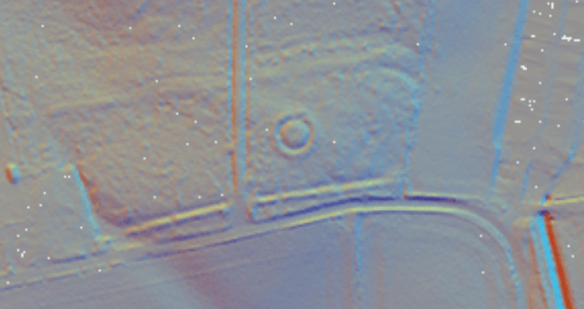
👁 What survives: Woodland earthworks marking the tower enclosure, with a surviving Roman road nearby. There is no standing timber tower.
⭐ Best for: Seeing how a watchtower related to a military road and a larger Roman landscape.
🥾 Visit: The records place the remains in woodland north-east of Parkneuk Cottage. Visibility depends on vegetation. Use appropriate existing access routes, respect neighbouring homes and avoid forestry operations. The map pin marks the tower site, not parking or an entrance.
🏛 Nearby Roman places: Strageath fort, Innerpeffray East camp, Raith and Ardunie watchtower.
🗺 Google Map location · Trove site record · HES scheduled monument record · Roman Gask Project: Parkneuk Tower
Location from Trove, recorded to the nearest 10 metres. The pin does not mark the boundary of the scheduled monument.
Parkneuk at a glance
| Feature | Evidence and interpretation |
|---|---|
| Date | Probably late first century AD (Flavian); no closely dateable Roman object was recovered in the 1968 tower excavation. |
| Timber tower | Approximately 3.05 × 3.35 m between post centres in the fuller excavation report; three post-holes found, fourth inferred. |
| Defences | Clay bank about 2.74 m wide; ditch about 3.66 m wide; entrance facing north towards the road. |
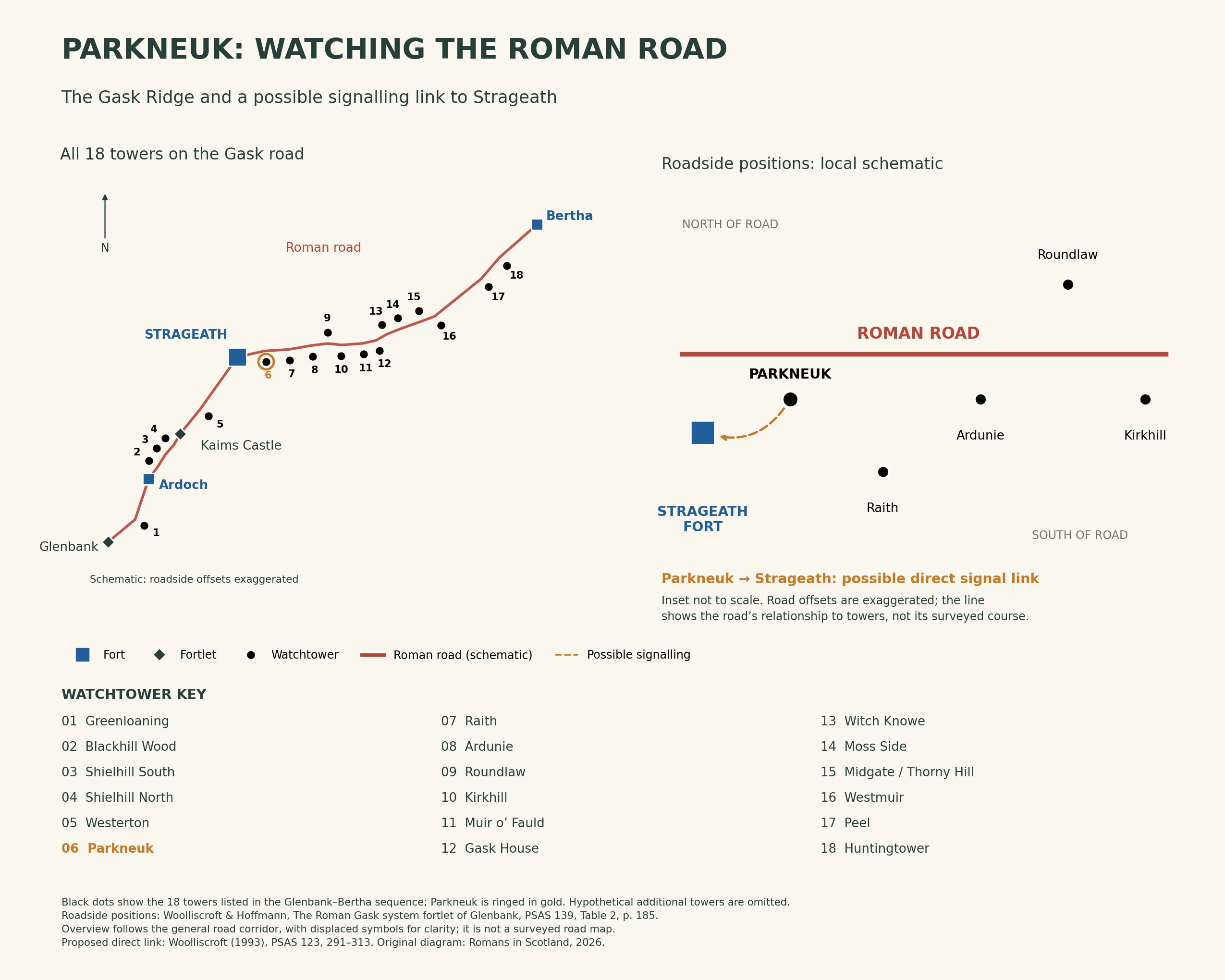
| Roadside position | South of the Roman road; approximately 25 m from it in the Glenbank report’s comparative table. |
| Possible communication | Direct visibility to Strageath in Woolliscroft’s signalling study. |
| Garrison | Unit and number of soldiers unknown. |
A small timber tower
Excavation in 1968 exposed the supports of a timber tower within a bank and surrounding ditch. Its northern entrance faced the road. The fuller excavation account gives a footprint of about 3.05 by 3.35 metres between post centres; the earlier summary reproduced in Trove gives 12 by 10 feet. The fuller account is followed here.
Waterlogging limited the investigation, and tree roots had disturbed the earthworks. Three post-holes were located; the fourth corner was reconstructed. These remains establish the ground plan more securely than the tower’s height or appearance above ground.
Watching the road
Parkneuk Wood preserves an important section of the Roman road. Investigations in 1967 and 1997 examined its construction, including layers of turf beneath the foundation stones. The published road report describes a gravel surface about 5.8 metres wide, raised in the middle to help shed water.
The road gave troops and supplies a route eastwards from the Earn crossing. From a post beside it, soldiers could observe movement and report what they saw. Pollen evidence from the road investigation suggested a relatively open Roman-period landscape: the present woodland should not be treated as a picture of the tower’s original surroundings.
The nearby camp adds another part of the story, but proximity does not demonstrate that camp, road and tower were all constructed or used at exactly the same time.
Parkneuk on the Gask Ridge
A possible direct link to Strageath
In Woolliscroft’s intervisibility study, Parkneuk could be seen from Strageath. This offers a possible direct communication link with the fort, unlike towers further east whose messages might have needed a relay through Raith.
The dashed arrow represents that interpretation. It depends on reconstructed tower heights and sightlines, with vegetation and weather affecting practical visibility. It does not establish which signals were used, how often messages were sent, or the precise duties of the men stationed here.
How securely is it dated?
Parkneuk is normally assigned to the Flavian period, in the late first century AD. The excavation produced no closely dateable Roman artefact. Robertson argued for that date from the similarity of its plan to Gask House, where a pottery fragment supplied dating evidence. That is a reasoned comparison, rather than an independently dated foundation or abandonment at Parkneuk.
References and further reading
Trove: Parkneuk, NRHE 26042 — location, surveys and the earlier excavation summary.
Historic Environment Scotland: SM2102 — the scheduled monument record, covering the signal station, road and camp earthworks. This HES record is now available through Trove.
Robertson, A. S. (1974), Roman ‘Signal Stations’ on the Gask Ridge: Parkneuk — account of the 1968 excavation, reproduced by the Roman Gask Project.
Woolliscroft, D. J. and Davies, M. H.: Parkneuk Wood Roman Road, excavations in 1967 and 1997 — with pollen evidence contributed by S. Ramsay.
Woolliscroft, D. J. (1993), ‘Signalling and the design of the Gask Ridge system’, PSAS 123, 291–313.
Woolliscroft and Hoffmann: The Roman Gask system fortlet of Glenbank, PSAS 139, 167–193, Table 2 — roadside positions used in the diagram.
← Gask Ridge frontier · Strageath Roman Fort · Ardunie Roman Watchtower

