Perth stands within one of the most important Roman military landscapes in northern Britain. The city itself did not exist in Roman times, but its location beside the River Tay explains why armies repeatedly operated in the surrounding area.
Amazing fact
When Inchtuthil was abandoned, the army buried a vast hoard containing hundreds of thousands of iron nails so the valuable metal could not be reused.
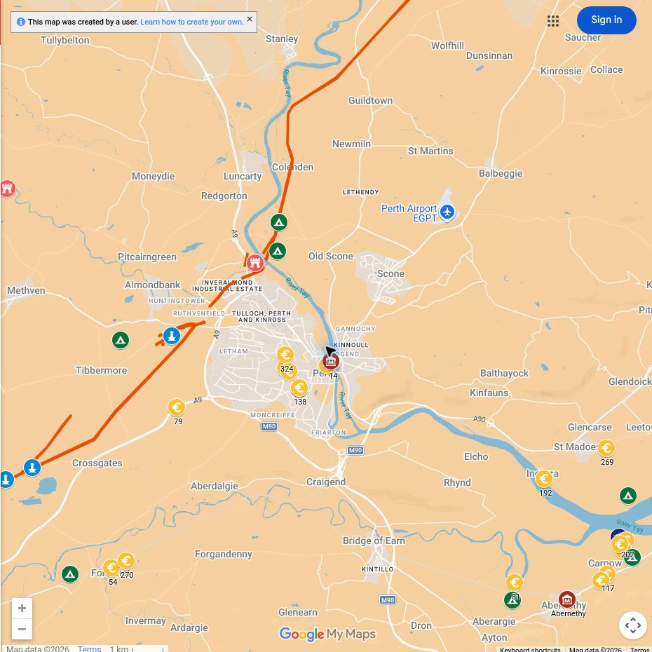
Nearby forts guarded crossings, roads and river traffic. To the south and west, the Gask system linked a chain of forts, fortlets and towers across Strathearn. North of Perth, the legionary fortress at Inchtuthil was intended to anchor Rome’s advance towards the Highlands. More than a century later, the fortress at Carpow supported the campaigns of the emperor Septimius Severus.
The result is not one Roman Perth but several overlapping military landscapes, created at different moments between the late first and early third centuries AD.
Why the Tay mattered
The Tay is both a route and an obstacle. It connects the interior of Scotland with the North Sea, while its crossings channel movement through particular places.
Roman commanders could use the river to transport people and supplies, although the details of naval operations remain imperfectly understood. Roads approaching the Tay linked forts to the south with Strathmore and the Highland edge. Controlling this network allowed the army to move, communicate and sustain campaigns far beyond the established province.
Bertha: guarding the crossing
Bertha Roman fort stood near the meeting of the Rivers Tay and Almond, just north of modern Perth. Its position allowed the garrison to supervise an important crossing and the routes leading into Strathmore.
The site was occupied in more than one Roman period. This repeated use reflects the continuing strategic importance of the Tay corridor rather than the uninterrupted existence of a Roman settlement.
Little can now be seen above ground, but Bertha is essential to understanding why the Perth area mattered. It connected the southern road system with forts farther north and with the wider river network.
Explore the forts of Perthshire and the Tay
The Gask system
South-west of Perth, Roman installations stretched through Strathearn. Forts at Ardoch and Strageath were accompanied by smaller posts and watchtowers along the Roman road.
This system belongs principally to the campaigns associated with Agricola in the late first century AD, although several sites were reused later. It is sometimes described as a frontier, but its precise purpose and chronology remain debated. The towers may have supported communication, observation and the protection of traffic along the road rather than forming a continuous defended barrier.
The Gask landscape is important because it shows Rome organising and monitoring movement north of the Forth before the construction of Hadrian’s Wall or the Antonine Wall.
Inchtuthil: a legionary fortress
About fourteen miles north of Perth, beside the Tay near modern Dunkeld and Blairgowrie, the army built the enormous legionary fortress of Inchtuthil.
It was intended for the Twentieth Legion and contained headquarters, barracks, workshops, granaries, officers’ houses and a hospital. Its scale represented a commitment very different from that of a temporary marching camp or auxiliary fort.
Yet Inchtuthil was abandoned before the intended occupation had fully developed. The withdrawal was systematic. A famous hoard of iron nails was buried, probably to prevent valuable metal falling into other hands. The decision reflects a change in imperial priorities rather than proof that the Roman army had been destroyed locally.
Carpow and the Severan campaigns
Carpow stands near the meeting of the Tay and Earn, south-east of Perth. Unlike Inchtuthil and the early Gask installations, it belongs principally to the campaigns of Septimius Severus and his sons in the early third century AD.
The substantial stone fortress probably housed legionary forces and served as a supply and operational base. Its position gave access to both river and land routes. Architectural fragments and inscriptions demonstrate the scale and status of the installation, although many questions remain about its exact development and abandonment.
Carpow shows that Roman interest in northern Scotland did not end with the abandonment of the Antonine Wall. More than a century later, emperors and armies again used the Tay as a route into the north.
Explore Carpow and Scotland’s other Roman forts
North from Perth
The military landscape continued beyond the immediate surroundings of the city. Cargill guarded the area around the confluence of the Isla and Tay, while Cardean and Stracathro lay on routes through Strathmore. Temporary camps record the movement of armies whose stays may sometimes have lasted only days.
These sites should not all be treated as components of one system operating at the same moment. Their dates, forms and functions differ. Together, however, they demonstrate how repeatedly Roman forces used the Tay and Strathmore corridors.
Step inside a Roman marching camp
What can you see today?
Much of Roman Perthshire survives as buried archaeology or cropmarks rather than standing masonry. A visit is therefore best approached as an exploration of landscape and museum collections.
- Perth Museum: the best local starting point for archaeological context and finds; check current displays before travelling.
- Bertha: an important archaeological location, but not a conventional visitor site with extensive visible remains.
- Carpow: principally understood through excavation, finds and the surrounding landscape.
- Ardoch: impressive surviving earthworks within travelling distance of Perth.
- Inchtuthil: a nationally important archaeological site, but visitors should check access and respect that it lies within working countryside.
Use the main map to understand the relationship between the Tay, the Gask road, Strathmore and the Highland edge. That wider view is more revealing than treating each site in isolation.

