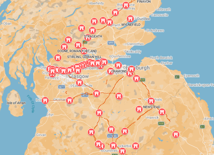
Roman forts in Scotland were not built as part of one single invasion.
For more than a century, Roman armies advanced into Scotland, withdrew, returned and sometimes rebuilt forts on exactly the same strategic sites. A fort first occupied during the campaigns associated with Agricola in the AD 70s and 80s might be brought back into use when Antoninus Pius ordered a new advance in the AD 140s. Some sites were used again during the campaigns of Septimius Severus after AD 208.
This page brings together the fort and fortlet pages on Romans in Scotland, arranged by area and campaign.
The underlying site list is based on the Romans in Scotland fort database and Roman Forts in Scotland. Dates should be treated as working archaeological dates rather than exact foundation and abandonment dates.
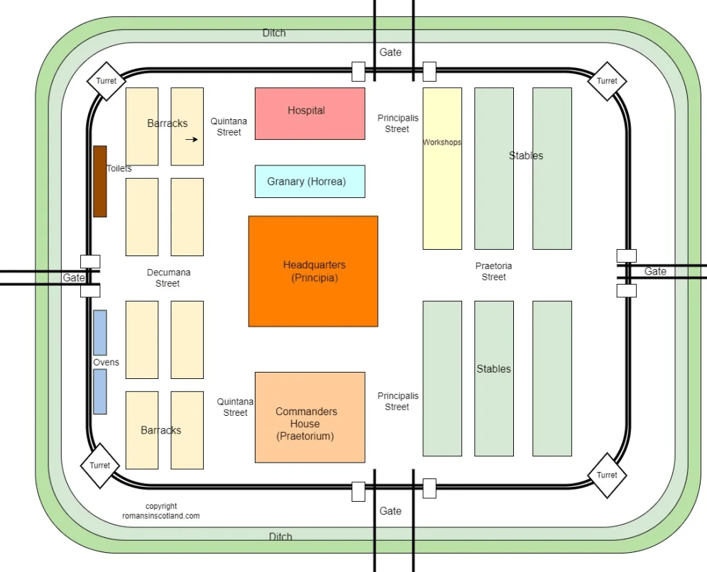
For an explanation of what the buildings inside a fort were used for, see Roman Fort Layout.
The Roman campaigns in Scotland
Three periods are particularly important when looking at the forts.
| Campaign | Approximate date | What happened |
|---|---|---|
| Flavian/Agricolan advance | c. AD 70s–90s | Roman armies occupied southern Scotland, advanced to the Tay and established forts, roads and the Gask military system. |
| Antonine occupation | c. AD 140–165 | Roman forces returned north of Hadrian’s Wall, reoccupied some older positions, established many new forts and built the Antonine Wall. |
| Severan campaigns | AD 208–211 | Septimius Severus assembled a huge army for renewed campaigning in northern Scotland. Cramond and Carpow were particularly important bases. |
A site can therefore appear in more than one Roman period.
South-west Scotland: Annandale, Nithsdale and Galloway
The valleys of south-west Scotland were major routes into the country. Roman roads ran north from the Solway through Annandale and Nithsdale, with forts controlling river crossings, junctions and movement through the Southern Uplands.
| Fort or fortlet | Working date | Main period and notes |
|---|---|---|
| Birrens Roman Fort | AD 75–184 | One of the major forts north of Hadrian’s Wall, with several phases of occupation. Also see the Second Cohort of Tungrians. |
| Broomholm Roman Fort | AD 80–120 | Early Roman fort in Eskdale. |
| Burnswark Roman Camps | Probably c. AD 140; debated | Roman camps and a fortlet around an Iron Age hillfort; recent research favours an assault interpretation. |
| Carzield Roman Fort | c. AD 142–158; approximate | Antonine cavalry fort; probably around 500 mounted troops, with the regiment’s name uncertain. |
| Dalswinton Roman Forts | Late first century AD | Successive Flavian forts in Nithsdale; the detailed sequence and proposed cavalry-unit identification remain debated. |
| Drumlanrig Roman Fort | Mid-second century AD | Antonine occupation is confirmed; a possible earlier Flavian phase remains unproven. |
| Gatehouse of Fleet Roman Fortlet | AD 80s; approximate | Small Flavian fortlet, probably occupied by an unidentified detachment. |
| Glenlochar Roman Fort | Late first century; AD 140s onwards | Fort rebuilt in the Antonine period, with an annexe and several nearby camps. These were separate episodes of activity. |
| Ladyward Roman Fort | Chronology uncertain | Roman fort with evidence for changing defences; its occupation dates and garrison are not securely known. |
| Milton Roman Forts | Late first century; Antonine reuse | Overlapping forts near Beattock, followed by a much smaller Antonine road post. |
| Raeburnfoot Roman Fort | Mid-second century AD | Small Antonine fort within a larger enclosure of less certain date and purpose. |
| Barburgh Mill Fortlet | AD 142–158 | Small Antonine-period road fortlet rather than a full-sized fort. |
These southern routes remained important when the main frontier moved north to the Antonine Wall. A frontier across central Scotland still needed secure roads and supply bases behind it.
Clyde Valley, Ayrshire and Renfrewshire
A second route approached the Forth–Clyde isthmus through the Clyde valley and the western lowlands.
| Fort | Working date | Main period and notes |
|---|---|---|
| Barochan Hill Fort | c. AD 80s–150s | Roman fort west of the later Antonine Wall. Early occupation has been proposed, making it important to the question of Roman control of the Clyde–Forth isthmus before the Wall. |
| Bishopton / Whitemoss Roman Fort | AD 140–158 | Antonine-period fort overlooking the Clyde. There is also an older Whitemoss site page. |
| Bothwellhaugh Roman Fort | c. AD 142–mid-160s | Antonine fort and bath-house; an inscription refers to an unnamed auxiliary cohort. |
| Castledykes Roman Fort | AD 80s; AD 140s–160s | Substantial fort occupied in Flavian and Antonine phases, with interruptions. A seal connects it with ala Sebosiana. |
| Crawford Roman Fort | c. AD 80/81–after 87; c. 140–165/170 | Upper Clydesdale fort with separate Flavian and Antonine occupations and later enlargement. |
| Loudoun Hill Roman Fort | Flavian; Antonine reuse | Successive enclosures beside the Irvine; the fort was subsequently destroyed by quarrying. |
| Mollins Roman Fortlet | AD 80s; approximate | Small Flavian fortlet predating the Antonine Wall. |
The Borders, Tweeddale, Lothian and Edinburgh
Eastern armies advancing into Scotland could move north along Dere Street, while other routes led through Tweeddale towards the Forth.
Flavian and later forts
| Fort | Working date | Main period and notes |
|---|---|---|
| Cappuck Roman Fort | AD 80–165 | Fort on Dere Street with a long and complex sequence of Roman activity. |
| Easter Happrew Roman Fort | AD 80s; approximate | Flavian fort in Tweeddale, distinct from the later Antonine fort at nearby Lyne. |
| Elginhaugh Roman Fort | c. AD 79–87 | One of Scotland’s best understood Flavian forts because its occupation was unusually short. |
| Inveresk – Roman Musselburgh | c. AD 80–158 | Major Roman military and civilian centre overlooking the Forth, with more than one period of Roman activity. |
| Lyne Roman Fort | c. AD 148–158 | Antonine fort in Tweeddale, close to the earlier fort at Easter Happrew. |
| Newstead / Trimontium | c. AD 80–180 | One of the most important Roman sites in Scotland, repeatedly occupied from the Flavian into the Antonine period. See also New survey of the Roman fort at Newstead and The Trimontium Story. |
| Oakwood Roman Fort | c. AD 80–100 | Flavian fort in the Scottish Borders. |
| Cramond Roman Fort | c. AD 140–310 | Fort on the Forth occupied in the Antonine period and dramatically reoccupied during the Severan campaigns. |
| Castle Greg Roman Fortlet | First or second century; uncertain | Small Roman fortlet near West Calder, with surviving earthworks but insecure occupation dates. |
Newstead is a particularly good example of why Roman forts cannot always be assigned to a single campaign. The Romans repeatedly returned to the same strategically useful place.
The Forth–Clyde isthmus before the Antonine Wall
Tacitus tells us that during Agricola’s campaigns the narrow land between the Forth and Clyde was held by Roman garrisons.
That does not, however, mean that every later Antonine Wall fort stood on an Agricolan fort.
Modern archaeology has found surprisingly little firm structural evidence for an unbroken chain of first-century forts directly underneath the later Wall.
The clearest example is:
Camelon Roman Fort
Camelon, immediately north of the later Antonine Wall near Falkirk, was occupied in the Flavian period, probably from the late first century AD, and again during the Antonine occupation.
It therefore really did exist decades before the Antonine Wall.
Barochan Hill west of the later frontier and Elginhaugh to its east also form part of the wider early Roman military landscape.
This distinction becomes particularly important when we look at the Antonine Wall itself.
The Antonine Wall forts
Construction of the Antonine frontier began following the renewed conquest of southern Scotland under the governor Quintus Lollius Urbicus. Roman campaigning was probably largely complete by AD 141, with construction of the new frontier beginning around AD 142.
The completed frontier eventually contained a remarkable concentration of forts.
From west to east the recognised forts are:
| Antonine Wall fort | Main page | What is especially interesting? |
|---|---|---|
| Old Kilpatrick | Old Kilpatrick Roman Fort | Western terminal fort and traditionally one of the first or primary forts. |
| Duntocher | Duntocher Roman Fort | A fortlet came first, followed by the very small fort. The fort itself existed before the Wall rampart reached the site. |
| Castlehill | Castlehill Fort | Recent survey indicates a fortlet phase and shows that the later fort was initially free-standing before the Wall joined it. |
| Bearsden | Bearsden Roman Fort | The original large enclosure was altered while it was being built, creating a smaller fort and an annexe. See also Bearsden Bath House. |
| Balmuildy | Balmuildy Fort | One of the earliest primary forts. Its unusual stone defences and wing walls show that it was constructed in advance of the Wall joining it. |
| Cadder | Cadder Roman Fort | Antonine Wall fort. The spreadsheet gives a possible earlier date, but secure evidence for an Agricolan fort beneath it is lacking. |
| Kirkintilloch | Kirkintilloch Roman Fort | Important Antonine fort occupying a carefully selected position in the local Wall alignment. |
| Auchendavy | Auchendavy Roman Fort | Modern geophysics shows that at least its northern side had been built before the Wall arrived. Traditionally a candidate for the central primary fort. See also the altars found at Auchendavy. |
| Bar Hill | Bar Hill Roman Fort | Spectacular hilltop fort. Bar Hill rather than Auchendavy may have been the central fort in the first design. |
| Croy Hill | Croy Roman Fort | A small later fort. An underlying enclosure once thought to be Agricolan has now been shown to be Antonine, probably connected with surveying or construction. |
| Westerwood | Westerwood | Small fort belonging to the denser, developed Antonine system. Site of the altar dedicated by Vibia Pacata. |
| Castlecary | Castlecary Fort | One of the large primary forts and, like Balmuildy, provided with stone defences. |
| Rough Castle | Rough Castle Fort | One of the smaller forts added as the frontier plan developed. See also Bar Hill and Rough Castle by drone. |
| Falkirk | Roman Falkirk | Fort beneath the modern town. |
| Mumrills | Mumrills Roman Fort | The largest fort on the Wall. Geophysical evidence confirms that the earlier Antonine fort preceded construction of the Wall. See also Second Cohort of Thracians. |
| Inveravon | Inveravon Roman Fort | A small fort at the eastern end of the frontier system. Older classifications sometimes describe the site as a fortlet, but it is treated as a fort in current Antonine Wall research. |
| Carriden | Carriden | Large eastern fort and one of the traditional primary forts, although it lay beyond the physical end of the Wall rampart. |
Which Antonine Wall forts came before the Wall?
This sounds like a simple question, but there are actually two different meanings of “before the Wall”.
Forts that existed decades before Antoninus Pius
These belong to the first-century Roman campaigns.
Camelon is the clearest example close to the later Antonine frontier. Roman occupation there began roughly half a century before construction of the Antonine Wall.
Earlier Roman activity has been proposed at several other places, but it is important not to assume that every Antonine fort dated to Agricola simply because Tacitus says the Forth–Clyde isthmus was occupied by garrisons.
Indeed, at Croy Hill, an enclosure once identified as an Agricolan fort has subsequently been demonstrated to be Antonine.
Antonine forts built before the Wall reached them
This is something different.
The Roman army did not simply finish the entire turf rampart and then attach forts to it.
Forts, fortlets, roads, the ditch and the rampart were being constructed as parts of an enormous military engineering project, and the design itself appears to have changed while the work was under way.
Several forts therefore existed as military enclosures before the linear barrier was physically joined to them.
| Fort | Relationship with the Wall |
|---|---|
| Balmuildy | An early primary fort. Stone wing walls anticipated the later arrival of the Wall, and recent geophysics suggests it may initially have been completely defended as a free-standing fort. |
| Mumrills | The fort was constructed before the Wall. The Wall changes direction to meet it, while its own northern ditches demonstrate that the fort initially existed independently. |
| Auchendavy | Geophysical survey shows its northern defences were already present before the Antonine Wall ditch reached the fort. |
| Castlehill | The fort appears to have been a free-standing installation before the Wall was brought up to it. Recent work has also identified an earlier fortlet within the sequence. |
| Duntocher | Particularly revealing: an Antonine fortlet came first, then a small fort, and the Wall rampart subsequently reached the site. Duntocher shows that even a supposedly “secondary” fort could physically precede the rampart. |
These forts are therefore earlier than the Wall beside them, but they are not necessarily first-century Agricolan forts. Most belong to the same Antonine building project.
The first plan for the Antonine Wall
For many years archaeologists have argued that the Antonine Wall was originally designed with about six large forts, with smaller fortlets occupying the intervals between them.
As construction progressed, more forts were inserted into the system, and some fortlets were replaced.
The traditional first or primary forts are broadly:
| Position | Early fort |
|---|---|
| Western end | Old Kilpatrick |
| Kelvin crossing | Balmuildy |
| Central western sector | Auchendavy or Bar Hill |
| Denny Gap | Castlecary |
| Eastern central sector | Mumrills |
| Eastern end | Carriden |
The middle position remains debated between Auchendavy and Bar Hill.
Modern measurements also suggest that the original forts were not spaced as neatly as the traditional model once implied. Roman planners were responding to river crossings, hills, roads, lines of sight and strategic routes as well as measurement.
The most important point is therefore not that there was a perfect six-fort grid, but that:
the design of the frontier changed during construction.
Bearsden provides a particularly striking example because even the internal design of the fort was altered while building work was underway.
Antonine Wall fortlets
The first Wall design made extensive use of small fortlets, broadly comparable with the milecastles of Hadrian’s Wall.
Several survived even after additional forts were introduced.
| Fortlet | Page/evidence | Notes |
|---|---|---|
| Duntocher | See Duntocher Roman Fort | Fortlet preceded the fort. |
| Carleith | Carleith – Canmore | Excavators searching in 1980 narrowly missed it; modern geophysical survey has now identified the fortlet. |
| Boclair Road | Discovery of a Roman Fortlet at Boclair Road, Bearsden | Discovered in 2017 east of Bearsden fort. |
| Castlehill | See Castlehill Fort | Recent reinterpretation supports a fortlet preceding the fort. |
| Kinneil | Kinneil Fortlet | One of the best-known fortlets towards the eastern end of the Wall. |
| Croy Hill | See Croy Roman Fort | Fortlet and later fort lie unusually close together. |
Other known or probable Antonine Wall fortlets include Wilderness Plantation, Glasgow Bridge, Watling Lodge, Cleddans, Summerston, Seabegs Wood and Bonnyside.
The discovery of additional fortlets has strengthened the case that they formed a regular part of the first frontier design.
Bridgeness and the eastern end
Romans in Scotland also has a page for Bridgeness Roman Fort.
Bridgeness needs to be treated separately from the standard list of Antonine Wall forts.
The site is exceptionally important because the enormous Bridgeness Distance Slab was found there close to what is generally accepted as the eastern termination of the Wall rampart.
See Antonine Wall Distance Slabs.
Carriden, rather than Bridgeness, is normally included among the recognised major forts of the Antonine frontier.
Camelon: a fort behind the Wall
Camelon lay about a kilometre north of the Antonine Wall near Falkirk.
It is one of the most important forts for understanding the chronology of Roman Scotland because it had a clear Flavian occupation long before the Antonine Wall, followed by renewed occupation in the Antonine period.
A Roman road linked the area around Rough Castle towards Camelon, emphasising that the Antonine frontier worked as a wider military landscape rather than simply as a rampart with forts attached to it.
Stirling and the routes into the Highlands
North of the Forth, Roman forts controlled the routes leading towards the Highland glens and into Perthshire.
| Fort | Working date | Main period and notes |
|---|---|---|
| Bochastle | AD 80–85 | Flavian fort traditionally included among the “glen-blocker” forts guarding approaches to the Highlands. |
| Doune Roman Fort | AD 80–87 | Flavian fort controlling routes through central Scotland. |
| Drumquhassle Fort | AD 80–86 | Flavian fort close to Loch Lomond and the western Highland approaches. |
| Malling Roman Fort | AD 80s; approximate | Flavian fort and annexe beside the Lake of Menteith; later survey revised its known footprint. |
| Ardoch Roman Fort | c. AD 81–215 | One of the most spectacular surviving Roman earthworks in Britain, with several phases of military activity. See Tour of Ardoch Roman Fort and the CGI reconstruction of Ardoch. |
| Dalginross Roman Fort | AD 80–86 | Flavian fort controlling the route through Strathearn. |
Perthshire, the Tay and the Gask system
After crossing the Forth, Agricola’s armies moved into Strathearn and towards the Tay.
This produced one of the most remarkable Roman military landscapes in Scotland: forts, roads and watchtowers running through Perthshire.
See also Roman Gask Ridge Watchtowers.
| Fort | Working date | Main period and notes |
|---|---|---|
| Bertha Roman Fort | c. AD 80–158 | Major fort controlling the Tay near Perth; occupied again in the Antonine period. |
| Cardean Roman Fort | AD 80s; abandoned after c. 86 | Large Flavian fort near Meigle; its accommodation may have served more than one auxiliary unit. |
| Cargill Roman Fort | Flavian; possible later reuse | Fort near the Tay–Isla confluence. Later coins raise questions about reuse but do not prove continuous occupation. |
| Fendoch | AD 83–86 | Flavian fort near the entrance to the Sma’ Glen. |
| Stracathro Roman Fort | AD 80s; probably later-80s withdrawal | Flavian fort and annexe in Angus, distinct from the nearby temporary camp. The garrison remains unidentified. |
| Strageath Roman Fort | AD 83–158 | Particularly important because it was occupied in both the Flavian and Antonine periods. |
| Carpow | c. AD 202–215 | Large legionary fortress on the Tay, closely associated with the Severan campaigns. |
Inchtuthil
One major site does not appear in the fort spreadsheet but must be included in any guide to Roman forts in Scotland:
Inchtuthil Legionary Fortress.
Built beside the Tay during Agricola’s northern campaigns, this enormous fortress was intended as a permanent base for Legio XX Valeria Victrix.
It was abandoned before completion when Rome’s military priorities changed.
See also the Inchtuthil animation.
Septimius Severus and the last great invasion
By the early third century the Antonine Wall had long been abandoned.
In AD 208 the emperor Septimius Severus arrived in Britain and launched the last enormous Roman attempt to impose military power deep into Scotland.
Two Scottish bases are particularly important.
| Fort | Severan role |
|---|---|
| Cramond | An earlier Antonine fort on the Forth was dramatically reoccupied and expanded to support the Severan army. |
| Carpow | Large legionary fortress beside the Tay and one of the clearest archaeological signatures of the Severan campaigns. |
Other older roads and military sites could still be used by Roman forces, but Severus did not build another permanent frontier across Scotland comparable with the Antonine Wall.
After his death at York in AD 211, his sons abandoned the attempt at permanent conquest.
The uncertain Corstorphine site
The fort database also contains a tentative entry for Corstorphine, Edinburgh.
At present this should not be listed as a confirmed Roman fort.
There is good evidence for Roman movement through the western Edinburgh area between Cramond, the Lothian road network and the Forth, but the spreadsheet entry itself is marked as uncertain and does not yet have a secure Canmore fort record.
It is therefore best retained as a research question rather than added to the confirmed list.
Why did the Romans keep returning to the same places?
The map of Roman forts looks complicated because Roman Scotland itself was complicated.
The army repeatedly needed to control:
river crossings,
passes through hills,
roads north and south,
harbours and navigable rivers,
supply routes, and
places where several routes met.
The geography did not change simply because the Roman army withdrew.
That explains why places such as Newstead, Camelon, Strageath, Inveresk, Cramond and Ardoch could become important more than once.
The Roman occupation of Scotland was therefore not a single invasion followed by a retreat. It was a succession of changing military strategies spread across more than a century.
More fort resources on Romans in Scotland
| Subject | Page |
|---|---|
| Complete fort map | Roman Forts in Scotland |
| Fort chronology | Agricola Fort Chronology |
| How forts were arranged | Roman Fort Layout |
| All fort-category articles | Fort archive |
| Antonine frontier | The Antonine Wall |
| Building the Wall | Antonine Wall Distance Slabs |
| Perthshire frontier | Roman Gask Ridge Watchtowers |
| Roman military occupation timeline | 323 Years of Military Occupation |
| Fort bath-houses | Roman Bath Houses in Scotland |
| Amphitheatres associated with Roman centres | Amphitheatres in Scotland |
| Latrines and sanitation | Roman Toilets and Latrines |
A changing military landscape
The forts tell the history of the Romans in Scotland particularly well.
The Flavian forts record an army pushing into unfamiliar territory.
The Antonine forts and fortlets show something different: an attempt to organise and hold a permanent frontier across central Scotland.
And Cramond and Carpow reveal the enormous but short-lived military effort of Septimius Severus more than sixty years later.
Perhaps most strikingly, the Antonine Wall itself was not built according to one immutable blueprint.
Forts were started before the rampart reached them. Fortlets were replaced by forts. Forts were enlarged or reduced. Annexes were added. Roads were diverted. The spacing of installations changed.
The Antonine Wall was therefore not simply built.
It evolved while the Roman army was building it.

